Rugged Trails and Expansive Mountain Terrain
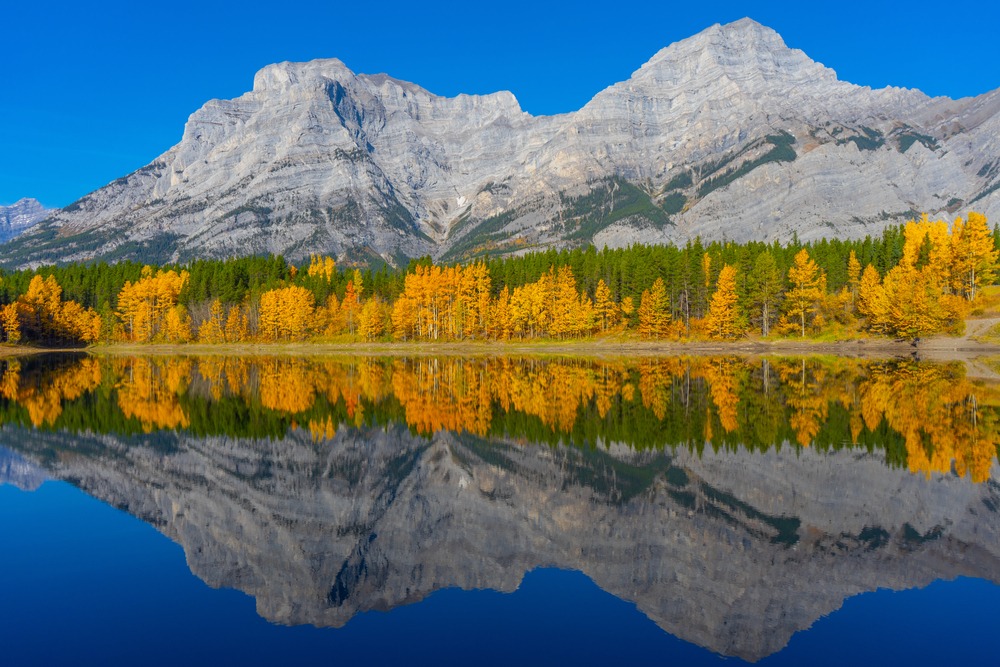
Spray Valley Provincial Park stretches along the long corridor of the Spray Lakes Reservoir south of Banff National Park. It protects a more rugged and expansive landscape than many first-time visitors expect, with steep ridgelines, broad alpine basins, long valley approaches, and a stronger sense of exposure than in some other parts of Kananaskis Country. Alberta Parks describes the park as extending south and west of Canmore around Spray Lakes Reservoir, with a wide range of hiking, wildlife viewing, and backcountry access spread along the corridor.
Spray Valley forms part of the wider regional system explored in Kananaskis Country: Alberta’s Provincial Parks, where valleys, ridgelines, alpine passes, and reservoir corridors connect across the larger landscape. Many hikes here follow old travel lines used by wildlife and mountain travelers moving between valleys along the eastern slopes of the Canadian Rockies. Today those same corridors still shape the feel of the hiking. Instead of converging toward one major viewpoint, many Spray Valley routes lead deeper into the mountains, where the terrain opens gradually and the scale of the landscape builds as the day unfolds.
Because the trailheads are spread along a long north–south corridor, Spray Valley often feels more distributed than Banff’s busiest areas. That does not always mean “easy” or “quiet” in every sense. It means the hiking is more spread out, more dependent on choosing the right trailhead and elevation band, and often more shaped by weather, route exposure, and current trail conditions. For a broader look at how this part of Kananaskis fits into a larger Rockies trip, How to Plan a Trip to the Canadian Rockies is a useful companion piece.
The following hikes highlight some of the most scenic and worthwhile routes in Spray Valley Provincial Park.
QUICK LOOK: SPRAY VALLEY HIKES
Best ridge hike: Tent Ridge
Best alpine pass hike: Smuts Pass
Best lake destination: Bull Lake
Best shorter scenic hike: West Wind Pass
Best long valley hike: Mount Shark to Watridge Lake
Best wildlife corridor hike: Commonwealth Creek
Best big alpine day: Smuts Pass to Birdwood Lakes
TENT RIDGE
Distance in and out: 10.5 km
Elevation gain: 820 m
Time to complete: 4 to 5 hours
Difficulty: Challenging
Tent Ridge is one of the most visually dramatic hikes in Kananaskis because it delivers sustained ridge travel rather than a single summit payoff. Recent route descriptions consistently frame it as one of the standout loops in Spray Valley, and that reputation makes sense. This is a hike that keeps unfolding as you move along it. The approach climbs steadily into alpine terrain, but the real reward begins once you gain the ridge and the route starts to arc above the valley in a broad horseshoe. From there, the views become nearly continuous. The reservoir stretches out below, Wind Mountain and the surrounding peaks fill the skyline, and the whole day takes on a more exposed, high-country feel.
What makes Tent Ridge special is not only the scenery, but the quality of the ridge itself. You are not simply climbing to a viewpoint and turning around. You are moving through a more immersive alpine line, with enough variety in the terrain to keep the day engaging from beginning to end. Hikers cross meadows, scree, and narrow ridge sections, and that variety is part of why the hike feels bigger than its numbers sometimes suggest. At the same time, it is not a casual outing. Exposure, footing, and weather all matter here, and stable conditions make a meaningful difference.
Tent Ridge is best for hikers who are comfortable with a stronger day and who want a route where the mountain experience is defined by openness, exposure, and scale. It is one of the clearest examples on this page of a hike that is worth choosing for the terrain itself, not just the destination.
WEST WIND PASS
Distance in and out: 4.4 km
Elevation gain: 220 m
Time to complete: 1.5 to 2 hours
Difficulty: Easy to Moderate
West Wind Pass is one of the best short alpine hikes in the region because it delivers a real mountain feel without requiring a full-day commitment. The trail climbs gradually through lower forest and open terrain beneath Mount Lougheed, then reaches a broad pass where the landscape suddenly opens into larger, more rugged country. Travel sources and route writeups consistently note how much scenery this hike gives for the effort, and that is really the key to its popularity. It feels alpine without becoming punishing.
This is a very good choice for hikers who want to step into Spray Valley terrain without committing to one of the bigger ridge or basin objectives. The openness at the pass gives the outing a satisfying sense of arrival, and Mount Lougheed, Windtower, and the surrounding ridges create a much stronger mountain frame than the relatively short distance would suggest. It is also a useful introductory hike for visitors who are still learning how Kananaskis terrain differs from more heavily trafficked national park trails.
West Wind Pass works especially well as a half-day objective, a shoulder-season outing when conditions allow, or a shorter hike on a day when bigger exposed routes do not make sense. If you are looking for a shorter guided day with strong scenery and a more manageable effort, Private Half-Day Guided Hikes in Kananaskis is the most natural next step.
SMUTS PASS
Distance in and out: 16 km
Elevation gain: 700 m
Time to complete: 5 to 6 hours
Difficulty: Challenging
Smuts Pass is one of the more memorable alpine approaches in Spray Valley because the day changes character so clearly as you move into it. The trail begins by following the Commonwealth Creek corridor, which gives the first part of the outing a more enclosed valley feel. You are moving up the drainage, gaining distance, and only gradually being introduced to the bigger terrain beyond. Then the upper approach steepens, the pass draws closer, and the whole route starts to feel more alpine and more consequential. Once you crest the pass, the basin beyond opens dramatically toward the Birdwood country. That transition is the essence of the hike.
What makes Smuts Pass so compelling is that it is both a complete objective in its own right and the gateway to bigger alpine terrain beyond. From the pass, Mount Smuts rises sharply to one side while the vertical face of Mount Birdwood and the basin beyond create one of the more dramatic pieces of scenery in this part of Kananaskis. Even hikers who do not continue farther often find the pass itself deeply worthwhile because of how strongly the terrain opens once they arrive.
This is a longer mountain day and best suited to hikers who are comfortable with distance, sustained effort, and a route that asks for more patience than a short ridge hike. It is not technically a casual outing, but for strong hikers it is one of the best ways to experience the scale and drama of Spray Valley.
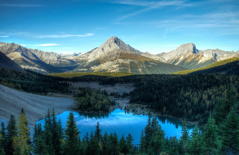
BULL LAKE
Distance in and out: 12 km
Elevation gain: 450 m
Time to complete: 4 hours
Difficulty: Moderate
Bull Lake is one of those quieter Spray Valley destinations that tends to appeal to hikers who prefer basin-and-lake days over ridge lines or summits. It does not carry the same immediate recognition as Tent Ridge or Smuts Pass, but that is part of its appeal. The hike asks you to move deeper into the terrain and let the day unfold more gradually. The lower travel is typically through forest and lower slopes, after which the terrain becomes more open and the surrounding ridges begin to define the setting more clearly.
Lake destinations in Spray Valley often feel quieter than equally scenic objectives elsewhere because the access points are more spread out and the routes themselves are not always chosen by casual visitors looking for a quick iconic stop. Bull Lake fits that pattern. The lake gives the outing a clear end point, but the value of the hike is also in the approach, the sense of moving away from the road corridor, and the way the surrounding ridges slowly begin to close in. On a calm day, the basin can feel peaceful in a way that suits hikers who want scenery without the performative atmosphere of busier destinations.
For moderate hikers who want a full-feeling day without committing to a highly exposed ridge or a very long alpine traverse, Bull Lake is a good middle-ground objective. It makes sense for hikers who value destination, rhythm, and a bit more quiet than the park’s most talked-about routes.
WATRIDGE LAKE
Distance in and out: 6 km
Elevation gain: 140 m
Time to complete: 2 hours
Difficulty: Easy
Watridge Lake is one of the gentlest hikes in the Spray Valley corridor, but it works best when understood clearly for what it is. Alberta Parks notes that the trail follows an old exploration road for 3.7 km to a junction, then continues a short distance to the lake. It also notes that there are limited views at the lake itself. That is useful and honest context. This is not a hike people choose for big alpine drama. It is a relaxed valley walk that offers easy access, a modest lake destination, and a straightforward outing from the Mount Shark area.
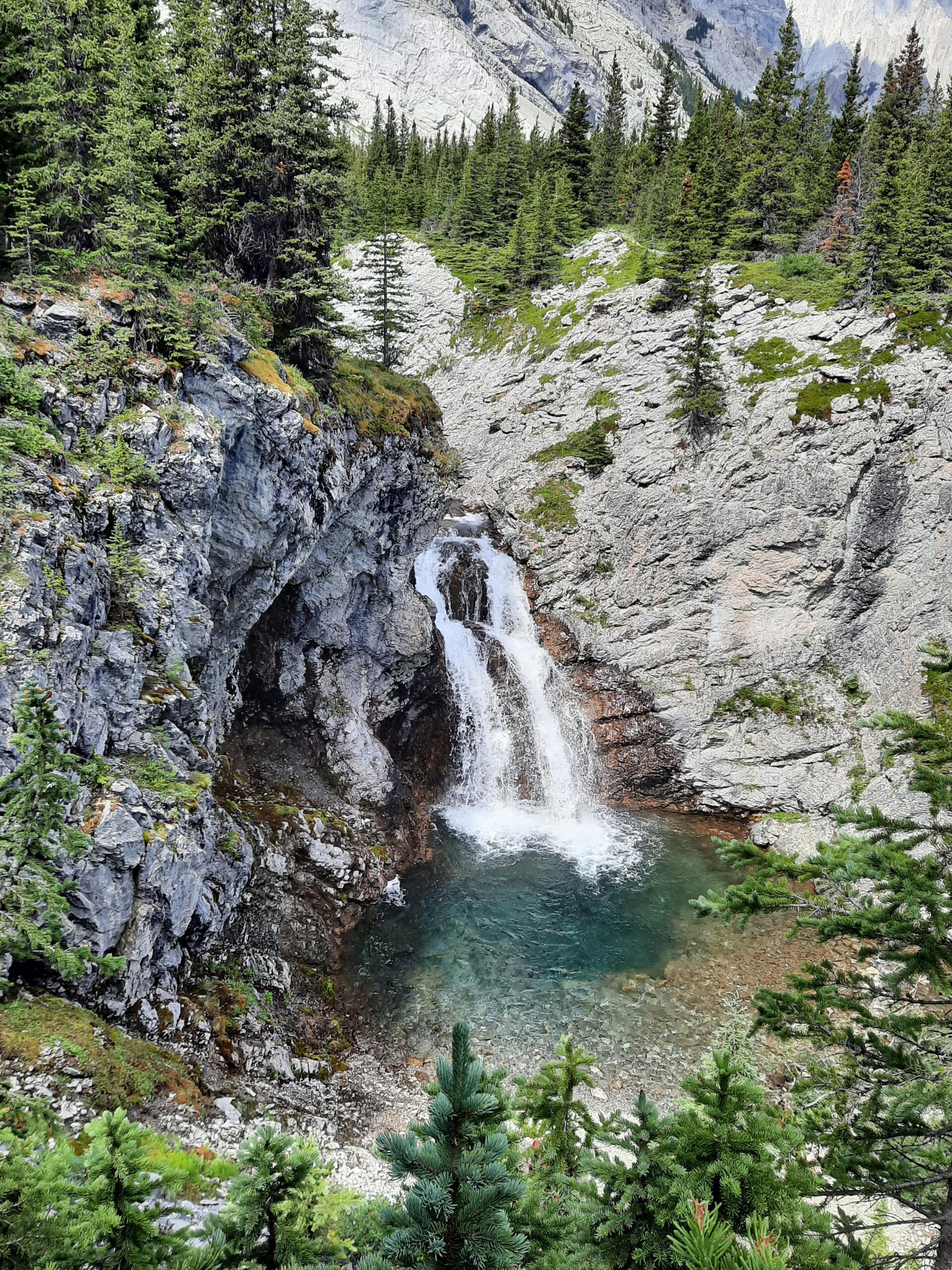
What makes Watridge worthwhile is its gentleness and usability. It is a strong option for hikers wanting a calmer day, for families or mixed-ability groups, or for visitors who simply want time on trail in a mountain setting without major physical demand. Recent trail-user notes also mention nearby waterfalls and the option to continue toward Karst Spring, which adds a little extra interest for people who want a slightly fuller outing from the same access area.
Watridge is best treated as an easy valley introduction to the Mount Shark side of Spray Valley rather than as a major scenic objective. That makes it useful. Not every worthwhile day in Kananaskis needs to be about scale. Some are about ease, access, and letting the mountains frame a more relaxed experience.
COMMONWEALTH CREEK
Distance in and out: 10 km
Elevation gain: 350 m
Time to complete: 3 to 4 hours
Difficulty: Moderate
Commonwealth Creek is one of the more interesting valley corridors in Spray Valley because it gives hikers a sense of traveling into bigger alpine terrain even when they are not continuing all the way to Smuts Pass or beyond. The drainage lies beneath Mount Smuts and Mount Birdwood, and that setting shapes the whole experience. Lower down, the route feels more like a long approach through a broad mountain corridor. Farther in, the surrounding walls become more imposing and the terrain starts to feel more obviously like the gateway to something bigger.
Trail-user descriptions note that parts of the lower route follow an old ATV road before narrowing along the creek, with creek crossings and route attention sometimes becoming part of the experience. That suits the character of the hike. Commonwealth is not a polished front-country trail. It feels more like a true valley approach into wilder country, and that is why it appeals to hikers who value atmosphere and terrain character as much as any single destination.
This is a good option for hikers who want a longer valley day with strong mountain walls and a sense of entering the back half of the landscape without necessarily committing to the full pass or basin beyond. It also helps explain why Spray Valley feels different from more accessible lake-and-meadow systems elsewhere in Kananaskis.
BIRDWOOD LAKES
Distance in and out: 20 km
Elevation gain: 850 m
Time to complete: 7 to 8 hours
Difficulty: Challenging
Birdwood Lakes is one of the biggest and most committing days on this page, and it feels like it. Reaching the lakes means first earning Smuts Pass, then continuing beyond into the basin behind it. That alone changes the nature of the outing. It is no longer just a valley approach or a pass objective. It becomes an alpine basin day of much greater depth and scale. Route descriptions consistently note the visual power of the basin beyond Smuts Pass, with Mount Birdwood rising dramatically above the lakes and the terrain feeling remote in a way that exceeds what many people expect from a day hike in Kananaskis.
The lakes themselves are not only the destination but also the reason the whole route feels different from simply hiking to the pass and turning around. Once you are beyond the pass, the country opens into something more severe and more alpine, with the lakes sitting in terrain that feels set back from the front of the range. That extra depth is the point. It is part of why Birdwood tends to stay memorable for strong hikers who are comfortable with longer alpine days.
This is not a casual recommendation. The distance, elevation, and terrain mean Birdwood Lakes is best suited to experienced hikers who want a truly full day and who understand that the effort is part of the reward. For the right person, though, it is one of the finest alpine basin outings in the valley.
MOUNT SHARK RIDGE
Distance in and out: 11 km
Elevation gain: 640 m
Time to complete: 4 to 5 hours
Difficulty: Challenging
Mount Shark Ridge offers a stronger viewpoint day above the Mount Shark trailhead area, with a route that starts more quietly and then steepens as it moves toward higher, more open ground. The Mount Shark area itself is well established in Alberta Parks as a year-round trailhead and recreation zone, and user descriptions note that once beyond the lower forest and valley travel, the ridge approach becomes significantly steeper and rougher. That pattern fits the overall feel of the hike: easier access at first, then a more serious climb toward better views.
What makes this route worthwhile is the contrast between the lower trailhead environment and the upper perspective once you gain the ridge. From above, the Spray Valley corridor and the mountains toward Assiniboine country feel broader and more connected. That is where the hike earns its place on a page like this. It is not just another climb near a parking lot. It is a chance to step above the valley floor and understand how much terrain opens beyond the Mount Shark zone.
Because the upper terrain is steeper and less forgiving, this hike is best for confident hikers who want more effort and more elevation than the easier Watridge-style outings nearby. It works better as a stronger full-feeling day than as a casual add-on.
WHICH SPRAY VALLEY HIKES SUIT DIFFERENT TYPES OF DAYS?
If you want a shorter scenic outing with strong mountain atmosphere, West Wind Pass and Watridge Lake are the easiest starting points. West Wind gives you the stronger alpine feel for the effort, while Watridge is the gentler valley walk and the better choice for a relaxed day.
For moderate hikers who want to move deeper into the terrain without committing to a major exposed ridge, Bull Lake and Commonwealth Creek make more sense. Bull Lake is better if you want a lake destination and a quieter basin feel. Commonwealth is better if you want a longer valley corridor and the sense of traveling into rugged country rather than simply arriving at a single feature.
For hikers seeking a bigger, more alpine objective, Tent Ridge, Smuts Pass, Birdwood Lakes, and Mount Shark Ridge all belong in the stronger category. Tent Ridge is the best ridge experience. Smuts Pass is the best alpine-pass objective. Birdwood Lakes is the biggest basin day. Mount Shark Ridge is the better choice if you want a challenging climb with broad views but not necessarily the same basin-and-pass structure. Choosing between them depends less on the headline scenery than on what kind of effort and exposure you want the day to carry. That is also where pacing becomes important. I explore that further in How to Pace a Hike in the Canadian Rockies.
PLANNING A HIKING DAY IN SPRAY VALLEY
The Spray Valley corridor sits at relatively high elevation and is exposed to changing mountain weather. Alberta Parks’ current Spray Valley trail report specifically warns hikers to practice wildlife safety, prepare for natural hazards such as downed trees and washouts, and expect route-finding to be necessary in places. Trail maps for the valley also note seasonal closures, including closure periods on the High Rockies and Spray West routes, which reinforces how strongly timing matters in this corridor.
Snow can linger on ridges and high passes into early summer, while autumn storms can arrive quickly later in the season. Conditions can also vary significantly between trailheads because the valley spans a long corridor with different elevations and terrain exposures. For that reason, route choice here is often more sensitive to current conditions than visitors expect. If you are trying to understand the bigger seasonal picture, Best Time to Visit Kananaskis for Hiking is the most relevant internal planning page. For reading weather more thoughtfully before heading into exposed terrain, How Hiking Guides Read Mountain Weather in the Rockies is also worth pairing with this article.
Visitors should also remember that travel within Kananaskis Country requires a Kananaskis Conservation Pass, including Spray Valley trailheads and parking areas.
WHAT TO KNOW BEFORE SETTING OUT
Spray Valley Provincial Park contains large areas of active wildlife habitat, and Alberta Parks’ current reports emphasize group travel, making noise, leashing pets, and carrying bear spray, even in winter. This is not just boilerplate. In long, lightly developed corridors like this, wildlife safety is part of the day rather than an afterthought.
Because trailheads are spread along the length of the reservoir and distances between them can be significant, it usually works better to focus on one part of the valley each day rather than trying to combine multiple trailheads into one outing. Spray Valley often rewards a more deliberate approach: pick one zone, one elevation band, and one kind of day, then let the route unfold from there.
A DIFFERENT SIDE OF KANANASKIS
Spray Valley Provincial Park offers some of the most rugged and expansive hiking terrain in Kananaskis Country. Ridgeline hikes, high alpine passes, long valley approaches, and large basins create a style of hiking that feels different from the lake basins, foothills forests, and gentler valley systems found elsewhere in the region. That difference is one of the park’s strongest qualities. It gives hikers a version of Kananaskis that feels broader, wilder, and more exposed without necessarily requiring deep backcountry travel.
For hikers who want to understand the landscape, ecology, and regional context more fully, Spray Valley Provincial Park is the best companion page to read alongside this one.
A GUIDE’S PERSPECTIVE
As a private hiking guide working across the Canadian Rockies, I spend much of the season moving through landscapes like these with guests who want a steady, well-paced day in the mountains.
Spray Valley is often chosen not only for its scenery, but for the kind of day the terrain creates. The longer corridor, the spread-out trailheads, the exposure on ridges and passes, and the way conditions shift with elevation all shape the rhythm of the experience. In a place like this, a well-matched day matters. The right outing depends on more than just which hike is most famous. It depends on weather, pace, timing, comfort with exposure, and the kind of mountain terrain a guest actually wants to spend time in.
If you prefer exploring these landscapes with experienced judgment and a calm, adaptable pace, you can learn more about my private guided hiking experiences in Kananaskis.
FAQ: SPRAY VALLEY PROVINCIAL PARK HIKING
WHERE IS SPRAY VALLEY PROVINCIAL PARK LOCATED?
Spray Valley Provincial Park lies south of Banff National Park within Kananaskis Country and follows the long corridor around Spray Lakes Reservoir, south and west of Canmore.
WHAT MAKES HIKING IN SPRAY VALLEY DIFFERENT FROM OTHER AREAS OF KANANASKIS?
Many hikes here involve long valley systems, exposed ridges, and alpine passes rather than gentler foothills or meadow-style terrain. The hiking often feels bigger, more spread out, and more rugged than in some other Kananaskis zones.
WHAT ARE THE MOST SCENIC HIKES IN SPRAY VALLEY PROVINCIAL PARK?
Tent Ridge, Smuts Pass, West Wind Pass, Bull Lake, and Birdwood Lakes are among the most memorable hikes in the valley, offering everything from short alpine passes to long basin days.
ARE SPRAY VALLEY HIKING TRAILS CROWDED?
Compared with some Banff-area trails, many Spray Valley hikes feel more distributed because trailheads are spread along a long corridor, though popular routes like Tent Ridge can still be very busy in good conditions.
WHEN IS THE BEST TIME TO HIKE IN SPRAY VALLEY PROVINCIAL PARK?
Most high routes are best in the snow-free season, but exact timing varies with snowpack, elevation, and current conditions. Check current reports before heading out. For broader timing context, Best Time to Visit Kananaskis for Hiking is the best internal next read.
DO I NEED A PASS TO HIKE IN SPRAY VALLEY PROVINCIAL PARK?
Yes. Vehicles parked within Kananaskis Country require a Kananaskis Conservation Pass.
ARE SPRAY VALLEY HIKES SUITABLE FOR MODERATE HIKERS?
Yes, but trail choice matters. West Wind Pass and Watridge Lake are good introductions, while Tent Ridge, Smuts Pass, and Birdwood Lakes are better for more experienced hikers.
CAN SPRAY VALLEY HIKES BE COMBINED WITH OTHER KANANASKIS AREAS?
Yes. Many visitors explore Spray Valley alongside nearby areas such as Peter Lougheed, Highwood Pass, or the broader Kananaskis system, but it is usually better to focus on one part of the valley per day rather than over-combining trailheads.
Certified private hiking guide and professional interpretive practitioner based in the Canadian Rockies. With over 25 years of four-season mountain experience, she offers thoughtfully paced hiking experiences that help active adults explore mountain landscapes with care, confidence, and understanding. Meet Niki