Remote Valleys of the Front Ranges
Elbow–Sheep Wildland Provincial Park protects one of the largest and most remote landscapes along the eastern slopes of the Canadian Rockies. It is a big piece of country, more rugged and less developed than many hikers expect, with broad drainages, long approaches, and a stronger feeling of distance from the front-country rhythm of more familiar Kananaskis areas. Alberta Parks describes the park as a natural, rugged alpine and subalpine landscape enclosed by high mountain ridges and stream courses that range from steep canyons to broad valleys.
Stretching south of the main Kananaskis valley system, the park holds a different kind of hiking experience. This is not generally where people come for quick iconic stops or short, high-traffic viewpoints. It is where you go when you want more space, longer lines through the landscape, and a day that unfolds gradually rather than giving everything away in the first thirty minutes. In places, the valleys feel expansive rather than dramatic. In others, the mountains close in and the terrain takes on a wilder, more enclosed feel. That contrast is part of what makes this area so compelling.
Because of its wildland designation, infrastructure is limited and the terrain often feels more remote than it is on a map. Trailheads are less built up, services are fewer, and once you move away from the road corridor the day quickly starts to feel quieter and more self-reliant. For hikers who are comfortable with longer valley travel and who appreciate a less managed feel, Elbow–Sheep offers some of the most spacious hiking in southern Kananaskis.
If you’re looking for a broader overview of the region and the kinds of private hiking days I offer there, explore my private guided hiking in Kananaskis page.
The following hikes highlight some of the most scenic and worthwhile routes in Elbow–Sheep Wildland Provincial Park.
QUICK LOOK: ELBOW–SHEEP HIKES
Best ridge hike: Mount Burns
Best alpine basin: Tombstone Lakes
Best valley hike: Sheep River Valley
Best glacier viewpoint: Jenkins Lake
Best quiet wilderness hike: Threepoint Creek
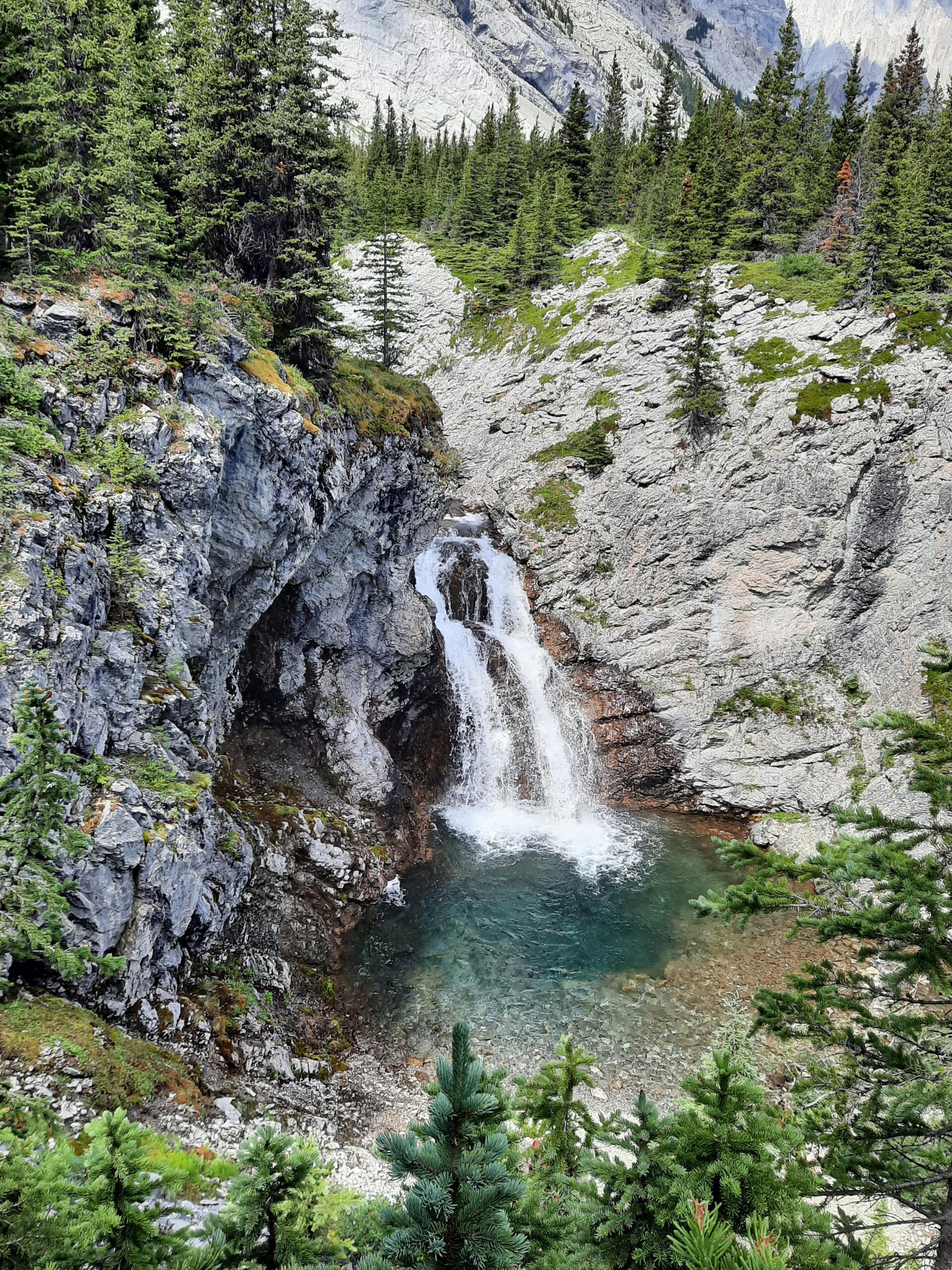
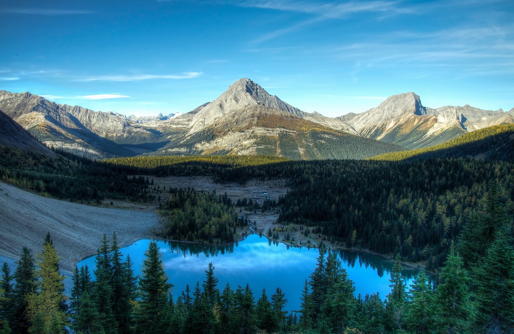
TOMBSTONE LAKES
Distance in and out: 10 km
Elevation gain: 450 m
Time to complete: 3 to 4 hours
Difficulty: Moderate
Tombstone Lakes is one of the most visually rewarding hikes in this part of Kananaskis because it combines a fairly approachable outing with a setting that feels properly alpine once you arrive. Alberta Parks notes that the trail leaves the Little Elbow Trail and follows Tombstone Creek up to the lakes, with access to the upper lake along the north side of the lower lake. That general line matters because the experience here is less about one continuous climb to a viewpoint and more about moving gradually deeper into the basin until the setting begins to gather around you.
The early part of the day tends to feel like access rather than destination. You move through lower terrain first, then deeper into the valley system, and only later does the character of the hike really sharpen. What makes Tombstone Lakes memorable is not a single dramatic reveal so much as the way the mountains begin to press in, the drainage narrows, and the basin finally opens beneath Tombstone Mountain and the surrounding limestone walls. Recent trail descriptions also note that sections can be rocky or muddy and that the upper approach feels steeper than the earlier valley travel, which fits the overall character of the route.
This is also one of the more popular outings in the southern Kananaskis area, and that is not hard to understand. The scenery is strong, the destination feels substantial, and the route works for both stronger day hikers and backpackers continuing deeper into the Tombstone backcountry. Even so, it still carries more of a remote valley feel than many heavily trafficked hikes elsewhere in the region. It is a very good choice for hikers who want a scenic alpine basin day without committing to a major ridge objective.
MOUNT BURNS
Distance in and out: 12 km
Elevation gain: 900 m
Time to complete: 5 to 6 hours
Difficulty: Challenging
Mount Burns is a different kind of day entirely. Where Tombstone Lakes is about moving into a basin, Mount Burns is about earning a ridge. The outing is more sustained, more physically demanding, and more exposed once you leave the trees. It is one of the stronger objectives in this southern Front Ranges zone, not because it is technically extreme by Rockies standards, but because it asks more of the hiker and gives its reward gradually. Recent trail descriptions characterize it as highly challenging, with sustained elevation gain and broad summit views over the Sheep River country.
The lower forested section is mostly about getting into position. The real personality of the hike begins when you gain the open slopes and the ridge starts to define the rest of the day. From there, the route becomes more about line, footing, wind exposure, and staying steady as the terrain opens out around you. Hikers who enjoy ridge travel tend to like Mount Burns not only for the summit itself, but for the feeling of moving upward into wider and wider terrain. The views are expansive in the way Front Ranges summits often are, with long sightlines over the Sheep River Valley and a broad sense of the country spreading away in every direction.
This is not the hike I would point casual visitors toward just because the distance looks manageable on paper. It is better suited to experienced hikers who are comfortable with sustained climbing, looser footing, and a day that becomes more committing as it goes on. For the right person, though, it is one of the most rewarding ridge days in the area and one of the clearest ways to experience the breadth of the southern Front Ranges.
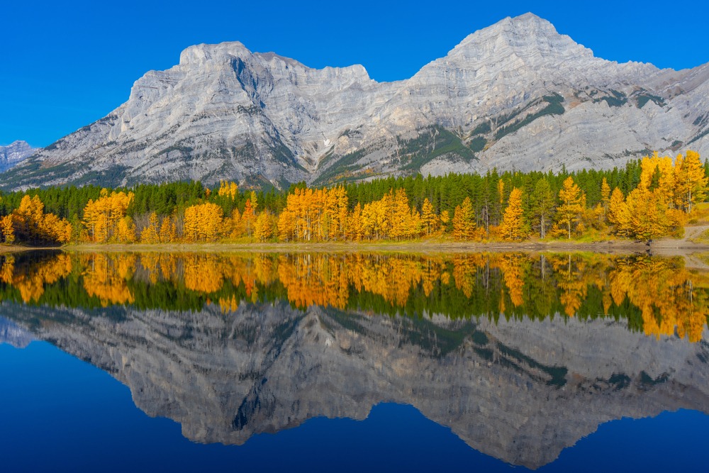
SHEEP RIVER VALLEY
Distance in and out: 14 km
Elevation gain: 250 m
Time to complete: 4 hours
Difficulty: Moderate
The Sheep River Valley is less about a single dramatic destination and more about the feel of traveling through a living mountain corridor. Alberta Parks notes that the Sheep trail travels through the Sheep River Valley from Sandy McNabb Campground toward Junction Creek Day Use and farther west beyond, and that matters because this is really a valley-travel experience rather than a viewpoint hike. The terrain is comparatively gentle, but the surrounding landscape gives the day its scale.
What makes this route worthwhile is the sense of movement through the valley itself. The river stays present. The peaks rise above the corridor rather than dominating it all at once. Openings and meadows break up the forested sections. In good conditions, it can feel like a very steady and absorbing walk through sheep country rather than a hike built around one obvious payoff. That is part of its appeal. It suits hikers who enjoy rhythm, distance, and landscape character more than summit-style achievement. Alberta Parks’ Sheep Valley map also shows how this drainage connects into a larger network of wildland routes and side valleys, which reinforces that sense of spaciousness.
Wildlife is part of the personality of this corridor too. This is one of those places where being early, quiet, and observant can change the feel of the day completely. It is also a good option for hikers who want to spend time in Elbow–Sheep without committing to the steeper elevation gain of a ridge or pass objective. On the right day, the value here is in the breadth of the valley and the steadier pace it allows.
JENKINS LAKE
Distance in and out: 12 km
Elevation gain: 500 m
Time to complete: 4 to 5 hours
Difficulty: Moderate
Jenkins Lake has the feel of a quieter destination hike rather than a marquee route. It suits hikers who like the idea of moving into a more enclosed alpine setting and ending at water rather than pushing for a ridge or summit. In the context of Elbow–Sheep, that kind of day matters. Not every strong hike in this landscape needs to be about gaining height for its own sake. Sometimes the better outing is the one that leads into a basin and lets the surrounding mountain walls do the work.
The character of a hike like this is usually built in stages. The forest travel establishes distance from the road, the middle section begins to feel more open and remote, and the final approach into the basin brings the sense of destination. That rhythm tends to work well for hikers who want a moderate day with a clear end point and a stronger feeling of quiet once they arrive. Compared with more talked-about Kananaskis objectives, a lake destination in this kind of terrain can feel more spacious and less performative, which is often exactly the point.
Because I was not able to verify Jenkins Lake with the same level of authoritative trail detail I found for Tombstone Lakes, Sheep River, or Threepoint Creek, I would keep the public-facing write-up here a little more restrained unless you have field notes of your own you want to fold in. Still, as a piece of the overall article, it works well as the lake-and-basin option for hikers who want a moderate effort and a calmer, less obvious destination.
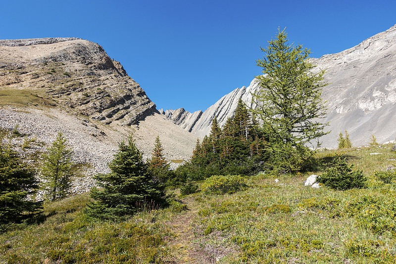
THREEPOINT CREEK
Distance in and out: 10 km
Elevation gain: 300 m
Time to complete: 3 to 4 hours
Difficulty: Moderate
Threepoint Creek is one of the better examples in this region of a hike whose appeal is tied to quiet country rather than high-profile scenery. Alberta Parks describes it as following Threepoint Creek through rolling foothills and notes that it connects into a larger loop with Hog’s Back Trail, while also warning that the trail lies on public lands and is not regularly maintained. That alone tells you quite a lot about the kind of day this is likely to be. It is less polished, less trafficked, and more dependent on comfort with a wilder feel.
That is exactly why some hikers like it. The draw here is not one giant viewpoint or iconic alpine basin. It is the cumulative experience of moving through a quieter drainage where the terrain feels more open-ended and less curated. The creek corridor, the rolling ground, and the relative lack of traffic all contribute to a day that feels spacious in a different way from the more famous parts of Kananaskis. It is a good choice for hikers who value atmosphere, solitude, and the feeling of being a little farther from the usual flow of visitors.
Because the trail is not regularly maintained, this is also a route where expectations matter. It suits hikers who are comfortable with a rougher trail character and who do not need every worthwhile day to be polished or obvious. In that sense, Threepoint Creek is very true to the wider Elbow–Sheep landscape. It offers a quieter wilderness day, not a packaged one.
WHICH ELBOW–SHEEP HIKES SUIT DIFFERENT TYPES OF DAYS?
For hikers looking for a moderate outing with a strong sense of destination, Tombstone Lakes is the clearest choice. It gives you a genuine alpine basin feel and a memorable setting without requiring the same level of effort or commitment as a ridge objective. Jenkins Lake fits a similar category, though in a quieter and more understated way, especially for people who prefer a lake-and-basin destination over a more dramatic summit-style day.
If what you want is steady movement through a large mountain landscape rather than one single payoff, Sheep River Valley is a better fit. It works well for hikers who enjoy distance, rhythm, and the experience of traveling through the terrain itself.
If you’re trying to choose between a steadier valley day and a stronger alpine objective, How to Pace a Hike in the Canadian Rockies may help you think through what kind of day fits best.
For stronger hikers who want elevation gain, ridge travel, and a more physically demanding objective, Mount Burns is the standout. And if your priority is simply to get into quieter country and walk in a landscape that still feels a little less managed and less visited, Threepoint Creek is the most natural choice.
For hikers interested in a longer day with more range and a deeper experience in the landscape, see my private full-day guided hikes in Kananaskis.
PLANNING A HIKING DAY IN ELBOW–SHEEP WILDLAND PARK
Because Elbow–Sheep protects remote terrain, conditions can vary more than many visitors expect. Access issues, seasonal closures, spring runoff, muddy sections, snow lingering in higher terrain, and trail maintenance levels can all shape what makes sense on a given day. Alberta Parks’ Tombstone page, for example, notes seasonal vehicle access limits to the primary trailhead from December 1 to May 14, which is the kind of detail that can materially change planning.
Late summer and early autumn often offer the most stable hiking conditions across much of this landscape, particularly for hikers who want drier trails and a more predictable footing pattern. Even then, these valleys and ridges are best chosen with current reports in mind rather than by reputation alone. Alberta Parks maintains current Kananaskis trail reports, and any vehicle parked in Kananaskis and the Bow Valley requires a Kananaskis Conservation Pass.
If you’re unsure when this part of Kananaskis tends to hike best, Best Time to Visit Kananaskis for Hiking gives a broader seasonal overview.
WHAT TO KNOW BEFORE SETTING OUT
The remote terrain of Elbow–Sheep Wildland Provincial Park asks a bit more of hikers than more developed front-country parks. Distances can feel longer than they look on paper, services are limited, and some trails have a rougher, less maintained character. That does not make the area inaccessible, but it does mean preparation matters more. Alberta Parks notes this explicitly on routes such as Threepoint Creek, where maintenance is limited.
Carry bear spray, check current trail conditions, and allow extra time for travel and route-finding. Cell coverage can be limited or unreliable, and this is not the sort of place where hikers should assume help, signage, or infrastructure will smooth over a poor planning decision. The reward for that extra self-sufficiency is a quieter and more spacious mountain experience than many busier areas can offer.
A WILDER SIDE OF THE FRONT RANGES
Elbow–Sheep Wildland Provincial Park protects one of the most expansive wilderness landscapes along Alberta’s eastern Rockies. The valleys run farther, the terrain often feels broader and less interrupted, and the sense of distance becomes part of the day itself rather than simply the space between trailhead and destination. Alberta Parks describes the park as a large wildland of rugged alpine and subalpine terrain, and that description feels accurate on the ground.
For hikers seeking a quieter and more remote mountain experience, these wildland valleys offer a memorable way to explore the southern Front Ranges of the Canadian Rockies. They are not always the easiest hikes to summarize in a single line, and that is part of their appeal. The best days here often come not from spectacle alone, but from space, rhythm, and the feeling of moving through a landscape that still keeps some of itself in reserve.
For hikers deciding between a quieter wildland experience and a more iconic national park day, Banff vs. Kananaskis for Hiking offers a helpful comparison.
A Guide’s Perspective
As a private hiking guide working across the Canadian Rockies, I spend much of the season moving through landscapes like these with guests who want a steady, well-paced day in the mountains.
Areas such as Kananaskis Country are often chosen not only for their scenery, but for how the terrain, timing, and visitor patterns shape the rhythm of a hiking day. In a region like Elbow–Sheep, that matters even more. Trail character, remoteness, seasonal access, and the difference between a valley day and a ridge day all affect whether the experience feels well matched or not. Understanding how those elements fit together is part of how thoughtful mountain days are designed.
If you’re planning to hike in this area and want a quieter, more personal day in the mountains, explore my private guided hiking experiences in Kananaskis.
If you’re looking for a shorter private mountain day with scenic reward and thoughtful pacing, you can explore my private half-day guided hikes in Kananaskis.
Certified private hiking guide and professional interpretive practitioner based in the Canadian Rockies. With over 25 years of four-season mountain experience, she offers thoughtfully paced hiking experiences that help active adults explore mountain landscapes with care, confidence, and understanding. Meet Niki