Front Range Trails of the Rockies
Bow Valley Provincial Park lies along the eastern edge of the Canadian Rockies between Calgary and Banff National Park. It forms part of the wider landscape of Kananaskis Country, a large network of provincial parks, recreation areas, and mountain corridors along the eastern slopes of the Rockies. In this stretch of the Bow Valley, foothills, river corridors, canyon systems, and Front Range ridges all begin to gather into something recognizably mountainous, but without immediately becoming deep alpine terrain. That transition is part of what makes this area so useful. It gives hikers a different kind of Rockies day.
While the higher peaks of Banff and the deeper valleys of Kananaskis often take most of the attention, Bow Valley Provincial Park and the surrounding corridor offer another style of hiking entirely. Trails here move through river flats, dry canyon bottoms, forested slopes, and ridge systems that reveal the mountain landscape gradually. You are often approaching the Rockies rather than starting in the middle of them. That gives the day a different rhythm and, for many people, a more comfortable beginning.
Because the terrain sits at lower elevation than many alpine areas, a number of these hikes become practical earlier in the season and remain useful later into autumn. For visitors arriving from Calgary or beginning a trip westward, the Bow Valley often works very well as a first hiking zone before moving deeper into Kananaskis or Banff. For a broader look at how this area fits into the provincial-park system, start with Kananaskis Country: Alberta’s Provincial Parks and Bow Valley Provincial Park. If you are trying to structure a larger trip through the region, How to Plan a Trip to the Canadian Rockies is the most useful planning companion.
The following hikes highlight some of the most scenic and worthwhile routes within Bow Valley Provincial Park and the surrounding Bow Valley corridor.
QUICK LOOK: BOW VALLEY HIKES
Best ridge hike: Yamnuska East End
Best wildlife corridor hike: Heart Creek Trail
Best short scenic hike: Grassi Lakes
Best valley trail: Bow River Loop
Best introduction hike near Canmore: Quarry Lake Loop
Best viewpoint hike: Ha Ling Ridge
Best forest hike: Grotto Canyon
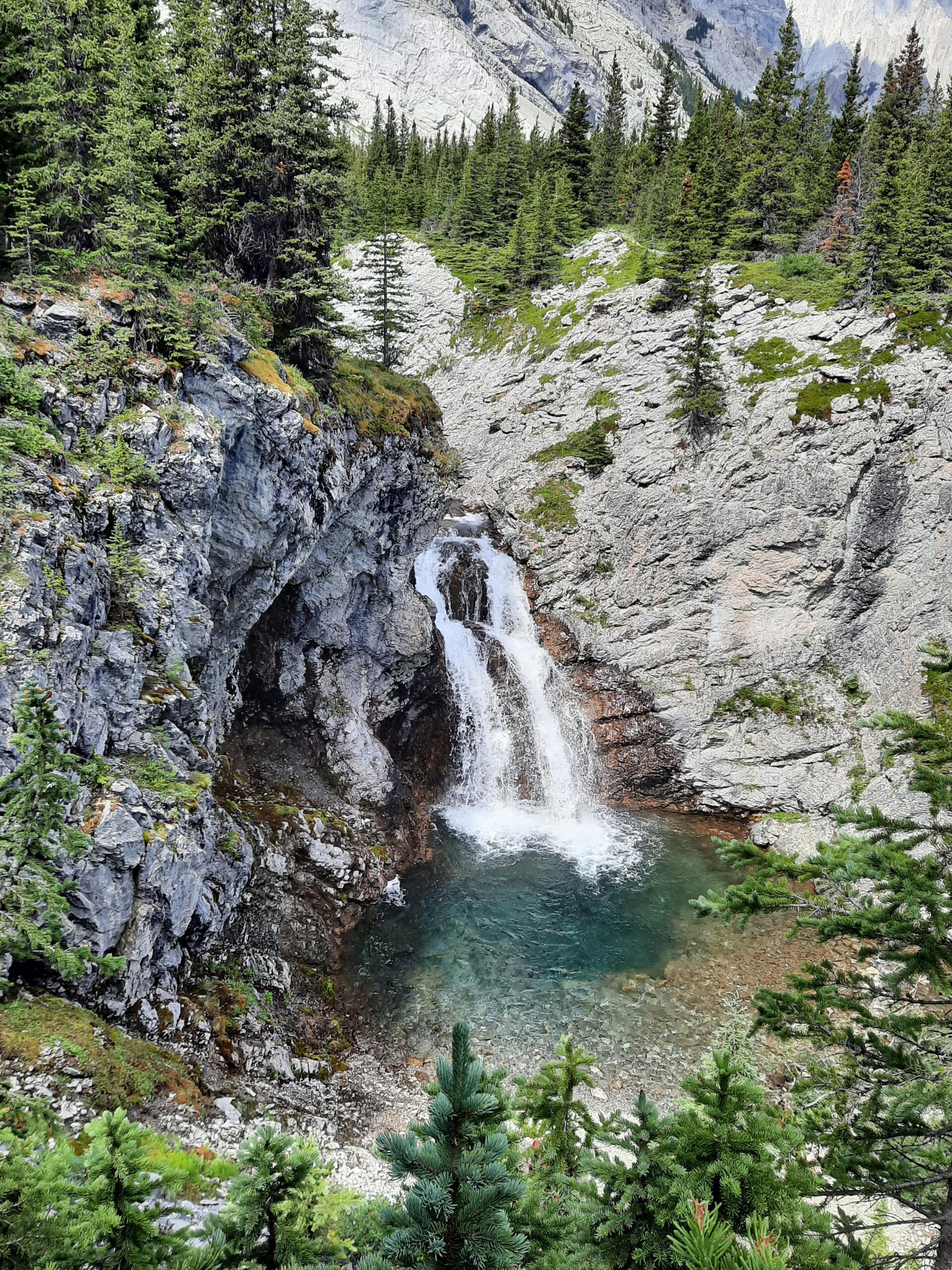
GRASSI LAKES
Distance in and out: 3.8 km
Elevation gain: 180 m
Time to complete: 1.5 to 2 hours
Difficulty: Easy to Moderate
Grassi Lakes is one of the most recognizable short hikes near Canmore, and Alberta Parks’ trail pages explain why it works so well for so many people. There are effectively two ways up: the easier Grassi Lake Upper route, which follows an old road through dense forest, and the more scenic Interpretive Trail, which climbs more gradually at first and then steepens, with views of a waterfall and the town of Canmore. Alberta Parks also notes that signs along the interpretive route tell the story of Lawrence Grassi, who built the original trail. That makes the outing more than just a quick scenic stop. It is one of the few short hikes in the area that combines vivid color, local history, and geological interest so directly.
What people remember most, of course, are the lakes themselves. The two striking turquoise lakes sit tucked beneath limestone cliffs, and that combination of water color, steep rock walls, and relative ease of access is what makes the hike so enduringly popular. You do not have to walk far before the payoff is obvious. At the same time, Grassi does not feel quite as casual as some short roadside stops because the trail still asks you to move upward into the setting rather than simply step out of the car and look. That small element of effort helps the destination feel earned.
This is one of the best introductory hikes in the Bow Valley for visitors who want dramatic scenery without committing to a full mountain day. It is also a good choice for people interested in landscape interpretation, rock climbing history, or simply starting a trip with a relatively short outing that still feels memorable. Because Grassi lies in a wildlife corridor, Alberta Parks also emphasizes that travel is restricted to designated trails in the area.
Learn More About Our Half-Day Grassi Lakes Hike in The Bow Valley
HEART CREEK TRAIL
Distance in and out: 6.5 km
Elevation gain: 220 m
Time to complete: 2 to 3 hours
Difficulty: Easy to Moderate
Heart Creek offers a gentler mountain corridor day west of Exshaw, and Alberta Parks currently distinguishes between the main Heart Creek trail and the shorter Heart Creek Interpretive route. The interpretive trail follows the narrow canyon over seven bridges to a hidden waterfall, while the broader Heart Creek area provides a longer, easier-moving foothills valley experience. That distinction matters because “Heart Creek” can mean different days depending on how far you go and what you want from the outing.
What gives Heart Creek its character is the way it stays approachable while still feeling close to the Front Ranges. The lower trail moves through forest and alongside the creek, and the canyon walls, bridge crossings, and climbing crags create a stronger sense of landscape than the modest numbers would suggest. The presence of rock climbers on the lower walls adds to the feel of the place without dominating it. It is a corridor where a lot of different forms of mountain movement are happening at once.
This is a good half-day hike for people who want a valley-and-creek experience rather than a summit or ridge objective. It works especially well for hikers easing into the Rockies, for days with mixed weather, or for anyone wanting a scenic outing that feels comfortably mountain-adjacent without becoming physically demanding early on. Alberta Parks also notes that the interpretive trail can be icy from October to May because of freeze-thaw conditions, which is exactly the sort of detail that makes this hike feel very different in shoulder season than it does in summer.
YAMNUSKA EAST END
Distance in and out: 6 km
Elevation gain: 500 m
Time to complete: 3 to 4 hours
Difficulty: Challenging
Mount Yamnuska is one of the most recognizable peaks in the Front Ranges, and Alberta Parks is very clear about the distinction between the East Ridge trail and the much more serious Yamnuska scramble route beyond Raven’s End. The East Ridge trail itself has gentler grades and scenic viewpoints, and it ends at Raven’s End, where a decision matrix sign is in place for those considering going farther. Alberta Parks specifically warns that many people have become lost and fatalities have occurred on the scramble route beyond. That is important context for how this hike should be described.
As a hike, the East End is compelling because it gives you direct exposure to the scale of Yamnuska without requiring you to commit to the mountain’s full scramble. The trail climbs steadily into open terrain, and from the ridge-end viewpoint the contrast between prairie foothills, Bow Valley forest, and the rising limestone wall of Yamnuska becomes very clear. It is one of the better places in the Front Ranges to understand how abruptly the mountain landscape can rise from the surrounding country.
This is best suited to hikers comfortable with steep, exposed terrain and with turning around where the hike ends rather than being drawn onward into terrain that exceeds their comfort or experience. That distinction makes the East End a worthwhile route in its own right, not just a lesser version of the full mountain. It is a very good example of a hike where judgment matters just as much as fitness.
GROTTO CANYON
Distance in and out: 4.2 km
Elevation gain: 100 m
Time to complete: 1.5 to 2 hours
Difficulty: Easy
Grotto Canyon is one of the more distinctive short hikes in the Bow Valley because it does not feel like a typical forest trail at all. Alberta Parks notes that the route begins by following a small powerline past an industrial plant before winding up a narrow canyon with vertical rock walls and a waterfall. That description explains a lot about why the hike can feel unusual at first. The start is not especially romantic. Then the canyon tightens, the walls rise, and the character of the day changes.
Once inside the canyon proper, the route becomes much more interesting. The broad, rocky creek bed, steep walls, and dry-canyon feel make it very different from many other shorter hikes near Canmore. The pictographs along the canyon walls add another layer of significance, though they are best approached with restraint and respect rather than treated as a casual photo stop. In colder months, the canyon is also known for ice formations and winter walking, which gives it a broader season than many short front-range hikes.
Grotto works well for hikers who want something geologically distinctive, relatively short, and visually different from the usual mix of forest and ridge. It is accessible to a wide range of hikers, but still interesting enough that it does not feel like filler on a Rockies trip. That combination is part of why it remains such a reliable recommendation near Canmore.
QUARRY LAKE LOOP
Distance in and out: 4 km
Elevation gain: 120 m
Time to complete: 1.5 hours
Difficulty: Easy
Quarry Lake sits on the edge of Canmore and is best understood as a scenic local loop rather than a “hike” in the stronger mountain sense. The Rocky Mountain Heritage Foundation describes it as one of Canmore’s favourite parks, with a walking trail, viewpoints, picnic areas, and broad recreational use, while current local trail descriptions emphasize the mountain scenery and the ease of the loop. It is a reclaimed landscape that has become one of the town’s most accessible and loved outdoor spaces.
What makes Quarry Lake worthwhile is not difficulty or remoteness, but immediate scenic value. The loop offers very good views toward Ha Ling Peak and the surrounding skyline, and because the lake is close to town it works well as a first-day walk, an easy evening outing, or a relaxed stop when a bigger trail is not the right fit. It is especially useful for visitors who want a sense of Canmore’s mountain setting without committing to a steep climb.
This is one of the best introduction walks in the Bow Valley for travelers arriving from Calgary, for mixed-ability groups, or for days when the goal is simply to move, breathe, and take in the mountain frame around town. It also pairs naturally with broader planning around foothills and front-range pacing. For that wider context, How to Plan a Trip to the Canadian Rockies is the best internal companion.
HA LING RIDGE
Distance in and out: 7.4 km
Elevation gain: 740 m
Time to complete: 3 to 4 hours
Difficulty: Challenging
Ha Ling is one of the iconic viewpoints above Canmore, and Alberta Parks currently notes that the maintained trail runs 3.5 km to the saddle, with the final 400 m and 103 m of gain to the peak on an unmaintained trail through loose, rocky terrain. That distinction matters because many people refer to the whole outing as one hike, but the maintained trail and the final summit push are not the same thing in character or risk.
The main body of the hike is a sustained climb. You work for the view here. The trail rises steadily through forest and then into more open terrain, and once the ridge or saddle is reached the perspective over Canmore and the Bow Valley opens dramatically. Mount Rundle, the Three Sisters, and the wider valley frame become part of the experience all at once, which is why Ha Ling feels so rewarding despite its relatively short overall distance.
Ha Ling is best for hikers who are comfortable with steady climbing and who understand that the summit itself, if continued to, involves looser and less maintained terrain. Even turning around at the maintained saddle gives a very strong outing. It is one of the clearest examples near Canmore of a hike where effort and payoff are closely matched.
BOW RIVER LOOP
Distance in and out: 5 km
Elevation gain: minimal
Time to complete: 1.5 to 2 hours
Difficulty: Easy
The Bow River Loop is the gentlest outing on this page and works best as a scenic river walk rather than a mountain hike in the usual sense. Recent route descriptions describe it as a wide gravel path with mountain views, several bridges, and the historic Canmore Engine Bridge, making it a very accessible walk for a wide range of visitors. While your draft frames this as part of the Bow Valley park experience more broadly, the feel here is much more river-corridor and town-edge than rugged backcountry.
That is not a weakness. In fact, the value of this route is precisely that it offers a relaxed way to experience the Bow Valley landscape with very little physical demand. River loops like this are useful at the beginning of a trip, after travel, on an easier recovery day, or for visitors who want scenery without committing to steeper terrain. Early in the morning, the corridor can feel especially calm, and the river itself gives the whole walk a sense of continuity that more destination-focused hikes do not always have.
For people trying to understand how the Bow Valley transitions from river corridor to foothill slope to mountain wall, this kind of easy walk can actually be more revealing than a harder climb. It lets the landscape unfold gradually, which is often the right starting point.
RUNDLE FOOTHILLS TRAIL
Distance in and out: 9 km
Elevation gain: 400 m
Time to complete: 3 to 4 hours
Difficulty: Moderate
The “Rundle Foothills Trail” is best understood as part of the broader Canmore and Rundle forebay / lower-slope trail environment rather than as one neat Alberta Parks trail page. Current public route descriptions around the Rundle Forebay area emphasize the wide, scenic trail feel, light crowds in places, and the way this side of Canmore offers reservoir, slope, and mountain-front views without immediately throwing hikers into steeper alpine terrain.
That makes this kind of outing valuable for hikers who want an intermediate day: something more than a simple riverside loop, but less concentrated and less intense than Ha Ling or Yamnuska East End. The eastern slopes of Mount Rundle create a strong backdrop, and as elevation or openness increase the view begins to pull eastward across the Bow Valley as well. The appeal here is not one singular dramatic summit, but the combination of quieter terrain, varied footing, and a good sense of the mountain’s lower flanks.
If you keep this hike on the page, I would continue to treat it as a quieter foothills-and-forebay style day near Canmore rather than trying to oversell it as a formal classic. Its value is in the pacing and scenery, not in headline status.
WASOOTCH RIDGE
Distance in and out: 11 km
Elevation gain: 780 m
Time to complete: 4 to 5 hours
Difficulty: Challenging
Wasootch Ridge is one of the classic early-season ridge hikes near the eastern gateway to the Rockies, but it is better documented through current route descriptions than through a single Alberta Parks trail page. Recent sources consistently describe it as a long ridge outing with the option to turn around at multiple points depending on conditions, energy, and comfort, and that is central to its character. This is not just one summit objective. It is a ridge day whose length and seriousness can expand or contract depending on how far you choose to continue.
The lower climb is steady and direct, but the real appeal begins once the ridge opens and the scale of the surrounding country becomes visible. From there, the outing feels much bigger than the trailhead setting suggests. You can look west toward the more substantial peaks of Kananaskis and east across foothills terrain that still carries the shape of the prairie edge. That dual perspective is one of the best things about Wasootch. It is a very good “gateway ridge” in the sense that it shows both where you are coming from and where the mountains begin to deepen.
Wasootch is best for hikers who are comfortable with sustained climbing, exposure to weather on open ridge terrain, and the discipline to turn around when the day or conditions call for it. Because the ridge can be followed for a long distance, this hike rewards judgment just as much as physical effort. For stronger effort days like this, How to Pace a Hike in the Canadian Rockies is the most relevant internal companion.
WHICH BOW VALLEY HIKES SUIT DIFFERENT TYPES OF DAYS?
For shorter scenic outings, Grassi Lakes, Quarry Lake, and the Bow River Loop are the clearest choices. Grassi is the most dramatic of the three, Quarry Lake is the easiest mountain-framed walk near town, and the Bow River Loop is the gentlest river-corridor option.
For moderate days, Heart Creek and the Rundle foothills-style terrain offer a good middle ground. Heart Creek is better if you want canyon, creek, and a sheltered valley feel. The Rundle lower-slope environment is better if you want a quieter, more open outing near Canmore without going all the way into a hard climb. Grotto Canyon also fits this middle category for many hikers, especially those more interested in geology and canyon character than in gaining elevation.
For stronger effort days with big viewpoints, Ha Ling, Wasootch Ridge, and Yamnuska East End are the standouts. Ha Ling is the most direct uphill push to a dramatic viewpoint above town. Wasootch is the best long ridge day of the three. Yamnuska East End is the one that most clearly demands comfort with steep, exposed terrain and disciplined decision-making at the end of the maintained hike. Choosing a route that matches both the season and your preferred pace can make the difference between a strong day and a needlessly hard one. This is exactly where pacing starts to matter. I explain that more fully in How to Pace a Hike in the Canadian Rockies.
PLANNING A HIKING DAY IN BOW VALLEY PROVINCIAL PARK
Because the Bow Valley sits at lower elevation than many alpine areas of the Rockies, hiking conditions here often become favorable earlier in the season. Alberta Parks’ Bow Valley Provincial Park trail reporting also highlights annual road closures on Bow Valley Park Road and seasonal restrictions in parts of the park, which is a useful reminder that “lower elevation” does not mean static access. Conditions and openings still vary through the year.
Spring and autumn can be especially pleasant times to explore Bow Valley trails, while summer weekends can bring more traffic and fuller parking lots on the most popular routes. Seasonal conditions across the region vary significantly with elevation, which is why a lower front-range or valley corridor hike can be a much better choice on some days than forcing a higher alpine plan. For broader timing context, Best Time to Visit Kananaskis for Hikingi s the best internal seasonal overview. For wider Rockies context, Banff Weather by Month is also helpful.
Visitors should also remember that areas within Kananaskis Country and the Bow Valley require a Kananaskis Conservation Pass for vehicle parking. Alberta Parks repeats that requirement across Bow Valley, Heart Creek, Grotto Canyon, Grassi Lakes, Ha Ling, and Yamnuska route information.
WHAT TO KNOW BEFORE SETTING OUT
Bow Valley Provincial Park and the surrounding corridor lie within an important wildlife connection zone between foothills and mountain terrain. Alberta Parks specifically notes wildlife corridor management areas in Bow Valley Wildland Provincial Park and at Grassi Lakes, where travel is restricted to designated trails only. That is not just administrative language. It reflects how ecologically important this landscape is.
Hikers should carry bear spray, remain aware of wildlife, and respect closures or seasonal restrictions designed to protect animals moving through the valley. Because many of these trails are close to Calgary and Canmore, parking areas can also fill quickly on summer weekends. Earlier starts often make the day feel calmer and more organized from the beginning. Alberta Parks’ current Canmore and Bow Valley reporting also shows how closures and seasonal restrictions continue to shape access across the area.
A DIFFERENT VIEW OF THE ROCKIES
Bow Valley Provincial Park offers a different perspective on the Canadian Rockies than many visitors first imagine. Rather than beginning deep in alpine terrain, hikers here often approach the mountains gradually through river corridors, foothills slopes, canyon systems, and ridges that build the sense of scale step by step. That transition from prairie edge to mountain wall is part of what gives these trails their particular identity.
This front-range style of hiking complements the higher alpine terrain found deeper in Kananaskis Country, including areas such as Peter Lougheed Provincial Park and Highwood Pass. For many travelers, these Bow Valley and Canmore-area routes provide a memorable gateway into the larger mountain world beyond.
A GUIDE’S PERSPECTIVE
As a private hiking guide working across the Canadian Rockies, I spend much of the season moving through landscapes like these with guests who want a steady, well-paced day in the mountains.
Areas such as the Bow Valley are often chosen not only for their scenery, but for how terrain, timing, elevation, and visitor patterns shape the rhythm of a hiking day. A lower front-range outing can be the right choice not because it is easier in some simplistic sense, but because it fits the season better, suits the group better, or creates a calmer and more enjoyable day than pushing into busier or higher terrain at the wrong moment.
If you prefer exploring these landscapes with experienced judgment and a calm, adaptable pace, you can learn more about my private guided hiking experiences in Kananaskis.
FREQUENTLY ASKED QUESTIONS ABOUT BOW VALLEY PROVINCIAL PARK HIKING
WHERE IS BOW VALLEY PROVINCIAL PARK LOCATED?
Bow Valley Provincial Park lies between Calgary and Canmore along the Bow River corridor and forms part of Kananaskis Country on the eastern edge of the Canadian Rockies.
WHAT ARE THE BEST HIKES IN THE BOW VALLEY AREA?
Some of the best-known hikes in the broader Bow Valley corridor include Grassi Lakes, Heart Creek, Quarry Lake, Grotto Canyon, Ha Ling, Yamnuska East End, and Wasootch Ridge, depending on the type of day you want.
IS BOW VALLEY PROVINCIAL PARK GOOD FOR BEGINNER HIKERS?
Yes. Easier options such as Quarry Lake, Bow River Loop, Grassi Lakes Upper, Grotto Canyon, and parts of Heart Creek make the Bow Valley one of the better places to begin hiking near Calgary and Canmore.
DO I NEED A PASS TO HIKE IN BOW VALLEY PROVINCIAL PARK?
Yes. Most parking areas in Kananaskis Country and the Bow Valley require a Kananaskis Conservation Pass.
WHEN IS THE BEST TIME TO HIKE IN BOW VALLEY PROVINCIAL PARK?
Because the area sits lower than many alpine zones, spring through autumn can all be useful, with earlier seasonal access than many higher hikes. Exact timing still depends on snow, freeze-thaw patterns, and current advisories.
If you want, send the next park article and I’ll keep the same format and level of detail so the whole Kananaskis cluster stays consistent.
Certified private hiking guide and professional interpretive practitioner based in the Canadian Rockies. With over 25 years of four-season mountain experience, she offers thoughtfully paced hiking experiences that help active adults explore mountain landscapes with care, confidence, and understanding. Meet Niki