Rugged Mountain Terrain and Expansive Valleys in Kananaskis Country
Visitors exploring the Canadian Rockies often begin their journey in Banff National Park or Lake Louise. Those landscapes are extraordinary, but they also concentrate much of the region’s visitor traffic.
Just south of Banff lies a vast mountain corridor where the scale of the landscape feels noticeably different.
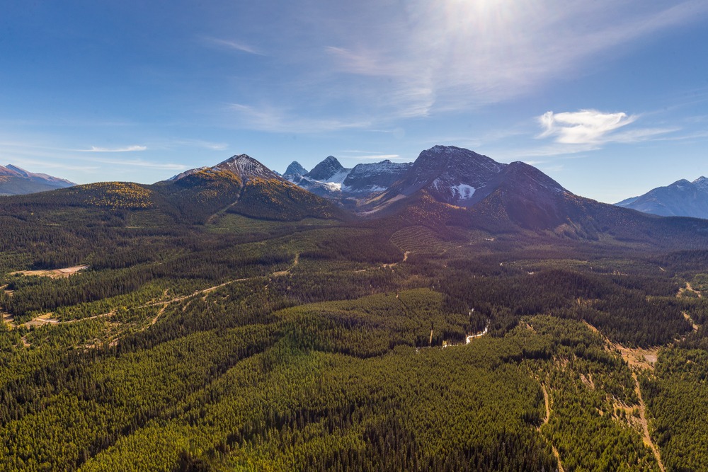
Spray Valley Provincial Park stretches along the dramatic Spray Lakes Reservoir and protects a long valley framed by steep mountain ridges, alpine basins, and high peaks rising from the eastern slopes of the Canadian Rockies. The terrain here feels rugged and expansive, with long valleys that extend deep into the surrounding mountains.
For hikers and travelers looking to experience large mountain landscapes without the same level of visitor concentration found in Banff’s most famous corridors, Spray Valley Provincial Park offers one of the most striking environments in Kananaskis Country.
To understand how this park fits into the wider region, see Kananaskis Country: Alberta’s Provincial Parks, which explores the network of provincial mountain parks stretching south from Banff.
For a broader view of how this valley fits into a full Rockies trip, see How to Plan a Trip to the Canadian Rockies, where terrain, distance, and pacing are considered together.
THE LANDSCAPE OF SPRAY VALLEY PROVINCIAL PARK
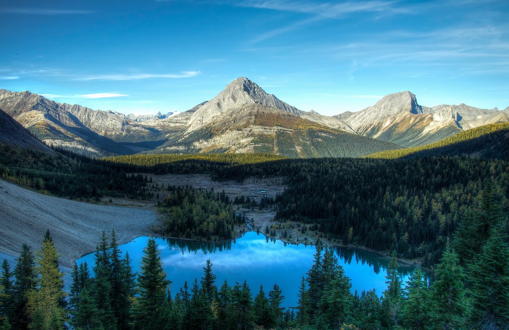
Spray Valley Provincial Park follows the long north–south corridor of the Spray River valley. The most prominent feature of the park is the Spray Lakes Reservoir, a large body of turquoise water that stretches for nearly 20 kilometers through the mountains.
Steep ridges rise directly above the shoreline, creating a dramatic contrast between the open water and the rugged mountain slopes above.
Unlike the wide alpine basins surrounding the Kananaskis Lakes valley to the south, the terrain in Spray Valley often feels steeper and more vertical. Many peaks rise sharply from the valley floor, creating striking silhouettes along the skyline.
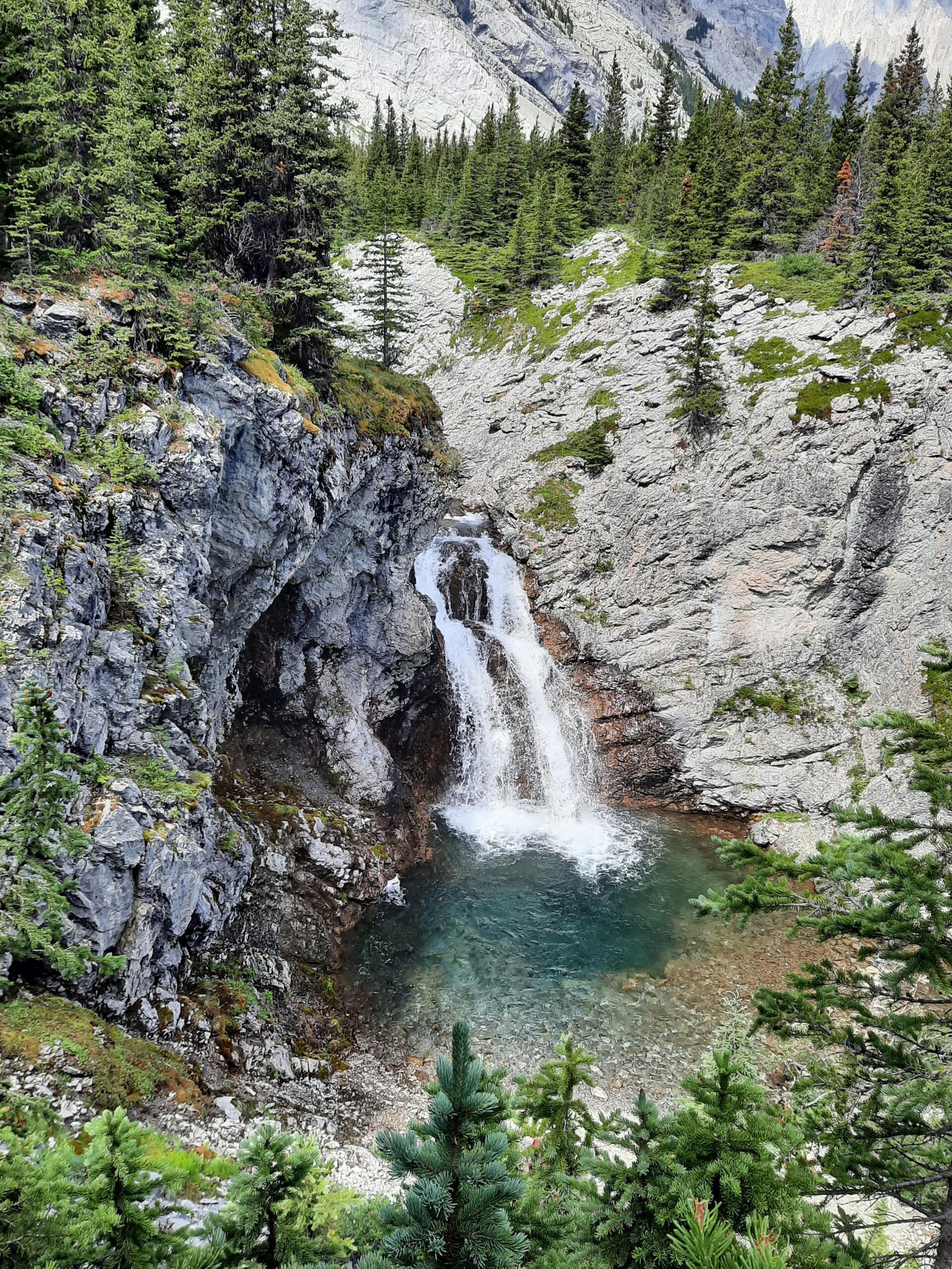
Several side valleys branch off the main corridor, leading toward alpine passes, glacial cirques, and high mountain basins. These valleys contain some of the most scenic hiking terrain in southern Kananaskis.
Because the valley stretches across a long distance and trailheads are spread out along the reservoir, visitors often find that the landscape feels surprisingly spacious even during the summer season.
HISTORY OF THE SPRAY LAKES RESERVOIR
One of the defining features of the Spray Valley landscape is the Spray Lakes Reservoir itself.
Originally a natural river valley, the area was transformed during the mid-20th century as part of a hydroelectric development project designed to generate power for southern Alberta. A series of dams created the long reservoir that now fills much of the valley.
Although the reservoir altered the original river system, the surrounding mountain landscape remains largely undeveloped. Today the reservoir reflects the peaks rising above the valley, creating one of the most dramatic lake-and-mountain vistas in Kananaskis Country.
The area now serves both as an important hydroelectric resource and a major recreation corridor within the provincial parks system.
ECOLOGY AND WILDLIFE OF SPRAY VALLEY
Spray Valley Provincial Park lies within an important wildlife corridor connecting Banff National Park with the southern ranges of Kananaskis Country.
The valley’s forests and alpine slopes support a variety of wildlife species, including elk, deer, black bears, and grizzly bears. Because the valley provides access between different mountain ranges, it functions as an important movement corridor for large mammals.
Lower elevations contain dense spruce and fir forests, while higher slopes transition into subalpine terrain and open alpine meadows.
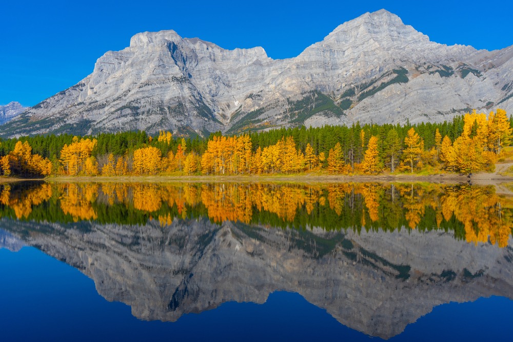
During summer months, wildflowers appear across many of the open slopes and basins. In early autumn, nearby alpine valleys containing larch trees turn golden, drawing hikers and photographers from across the region.
These ecosystems are shaped by short growing seasons and significant snowfall during winter, making responsible travel practices such as Leave No Trace especially important for protecting the landscape.
GEOLOGY OF THE SPRAY VALLEY MOUNTAINS
The mountains surrounding Spray Valley belong to the Front Ranges of the Canadian Rockies, a region formed during powerful tectonic compression roughly 80 million years ago.
During this process, layers of ancient seabed rock were pushed eastward along large fault systems. Over millions of years, glaciers carved the valleys and cirques that define the landscape today.
Many of the steep ridgelines rising above the Spray Lakes Reservoir are composed of resistant limestone and shale formations that erode slowly, leaving behind dramatic cliffs and rugged mountain profiles.
Glaciation played a major role in shaping the terrain visible today. The wide valley containing the reservoir and the cirques that branch off its sides were carved by glaciers during the last ice age.
These glacial processes created the long, dramatic valley that now defines the Spray Valley landscape.
SCENIC LANDSCAPES AND HIKING AREAS
Several alpine landscapes within Spray Valley Provincial Park have become particularly well known among hikers exploring southern Kananaskis.
Burstall Pass
A broad alpine valley that gradually climbs toward the Alberta–British Columbia border, framed by dramatic peaks and famous for its golden larch forests in autumn.
Chester Lake
A scenic alpine basin surrounded by open slopes and larch trees, located near the northern portion of the valley.
Rummel Lake
A quieter alpine lake tucked beneath steep mountain walls in a smaller side valley off the main corridor.
Tent Ridge
One of the most dramatic ridge walks in Kananaskis, offering sweeping views across the Spray Valley and surrounding peaks.
Sparrowhawk Tarns
A high alpine landscape of small glacial lakes and open slopes overlooking the reservoir below.
You can explore these routes in more detail in Spray Valley Provincial Park Hiking | Rugged Trails and Expansive Mountain Terrain
SEASONAL CHARACTER OF SPRAY VALLEY
Like much of Kananaskis Country, the character of Spray Valley Provincial Park changes dramatically throughout the year.
Spring often arrives slowly in the valley as snow melts from surrounding slopes. Waterfalls and streams run strongly during early summer as snowpack retreats from higher elevations.
Summer brings long daylight hours and clear views across the reservoir and surrounding ridges. Alpine trails become accessible as snow retreats from high passes and basins.
Early autumn introduces cooler air and the striking golden colors of alpine larch trees in nearby valleys such as Burstall Pass and Chester Lake.
Winter transforms the valley into a snow-covered landscape popular with backcountry skiers and snowshoers, although travel conditions can become more challenging due to heavy snowfall.
Understanding seasonal conditions can help visitors choose the best time to explore the valley.
For a broader seasonal breakdown across the region, see Best Time to Visit Kananaskis for Hiking.
WHY SPRAY VALLEY FEELS DIFFERENT FROM OTHER PARTS OF KANANASKIS
Each major valley in Kananaskis Country has its own character.
The Kananaskis Lakes region often feels broad and open, while Highwood Pass provides immediate access to alpine terrain.
Spray Valley sits somewhere between these two landscapes.
The valley’s long north–south orientation and dramatic ridgelines create a sense of scale that feels both expansive and rugged. Instead of gathering at one iconic destination, hikers move through large mountain terrain where valleys, ridges, and alpine basins gradually reveal themselves.
Because trailheads are spread across a long corridor and many routes extend deeper into the mountains, the hiking experience here often feels more dispersed than in some of the most famous national park locations.
A GUIDE’S PERSPECTIVE ON HIKING HERE
After guiding in the Canadian Rockies for many seasons, Spray Valley has always stood out as one of the most visually dramatic landscapes in southern Kananaskis.
The combination of the long reservoir, steep mountain ridges, and expansive alpine valleys creates a powerful sense of scale. On many days the mountains feel immense and the terrain encourages a steady, unhurried pace through the landscape.
When guests join me for private guided hikes in this area, the day often unfolds gradually — beginning beside the water and rising toward alpine terrain where views extend across multiple valleys.
If this part of Kananaskis feels like the right fit for your trip, you can explore my private guided hiking options here.
This is also where pacing begins to matter. I explore this further in How to Pace a Hike in the Canadian Rockies, where terrain, energy, and conditions shape how a day unfolds.
HOW SPRAY VALLEY FITS INTO A ROCKIES TRIP
Spray Valley Provincial Park sits between Banff National Park to the north and the Kananaskis Lakes valley to the south.
Because of this location, many travelers combine a visit to Spray Valley with time exploring other areas of Kananaskis Country.
Some visitors hike in Peter Lougheed Provincial Park before driving north into Spray Valley to experience a different type of mountain terrain. Others explore the valley while traveling between Banff and the southern Kananaskis region.
Either way, Spray Valley offers a powerful reminder that some of the most dramatic mountain landscapes in the Canadian Rockies lie just beyond the most famous destinations.
Frequently Asked Questions About Spray Valley Provincial Park
Where is Spray Valley Provincial Park located?
Spray Valley Provincial Park lies within Kananaskis Country, south of Banff National Park and west of Canmore along the Spray Lakes Road corridor. The park follows the long valley surrounding the Spray Lakes Reservoir and forms one of the major mountain corridors in southern Kananaskis.
What are the best hiking areas in Spray Valley Provincial Park?
Some of the best-known hiking areas in Spray Valley include Burstall Pass, Chester Lake, Rummel Lake, Tent Ridge, and Sparrowhawk Tarns. Together, these routes show the variety of the valley, from larch-filled alpine passes and quiet lakes to exposed ridgelines with sweeping mountain views. For trail-specific details, see Spray Valley Provincial Park Hiking | Rugged Trails and Expansive Mountain Terrain.
Is Spray Valley less crowded than Banff?
In many cases, yes. While some popular trails still attract visitors, Spray Valley often feels more spacious because trailheads are spread along a long mountain corridor rather than concentrated around one iconic destination. That geography changes the rhythm of the day and often creates a quieter experience than Banff’s busiest hiking areas.
Do visitors need a pass to visit Spray Valley Provincial Park?
Yes. Most vehicles parking within Kananaskis Country require a Kananaskis Conservation Pass. The pass helps support trail maintenance, visitor infrastructure, conservation work, and search and rescue across the region.
When is the best time to hike in Spray Valley Provincial Park?
Most hiking routes in Spray Valley are most accessible from late June through early October, although exact timing depends on snowpack and elevation. Mid-summer offers the widest trail access, while early autumn can be especially beautiful when larch trees begin turning gold in nearby alpine valleys.
Certified private hiking guide and professional interpretive practitioner based in the Canadian Rockies. With over 25 years of four-season mountain experience, she offers thoughtfully paced hiking experiences that help active adults explore mountain landscapes with care, confidence, and understanding. Meet Niki