Alpine Ridges and Wildflower Basins
Highwood Pass sits at 2,206 metres and marks the highest paved road crossing in Canada. Located along the southern portion of Kananaskis Country, it gives hikers unusually direct access to alpine terrain along the eastern slopes of the Canadian Rockies. Alberta Parks notes that Ptarmigan Cirque starts from the Highwood Meadows Day Use Area at the highest paved pass in Canada, which is exactly what makes this area feel so different from many other hiking zones in the region. You begin high, and that changes the character of the day almost immediately.
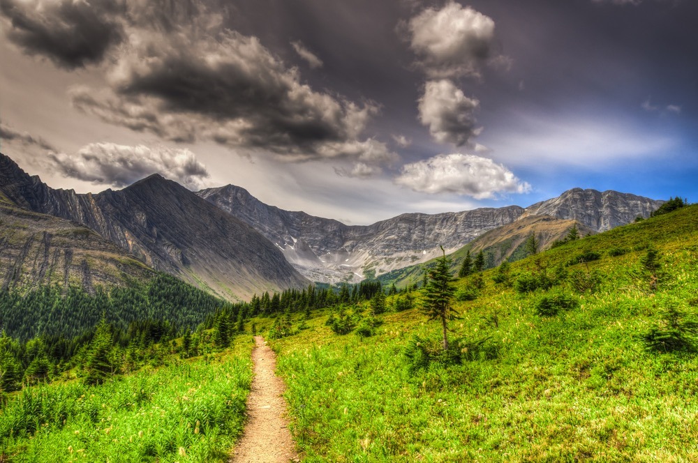
Because the road climbs directly into subalpine and alpine terrain, many Highwood Pass hikes reach open mountain landscapes far more quickly than trails that begin lower in forested valleys. Within a short distance, hikers can move from trees into broad alpine slopes, cirques, ridgelines, and high meadows framed by limestone peaks and rolling Front Range summits. That speed of transition is one of the area’s biggest strengths. Highwood Pass feels alpine early, and often all day.
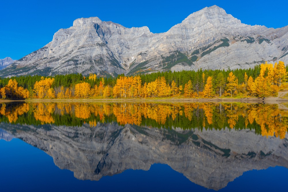
The area is particularly well known for wildflowers in midsummer and for larches later in the season, especially on and around Pocaterra Ridge. Current route descriptions still consistently point to Highwood as one of the best parts of Kananaskis for both summer bloom and autumn color.
To understand how this area fits into the wider region, see Kananaskis Country: Alberta’s Provincial Parks For a deeper look at alpine bloom timing and elevation patterns, see Wildflowers in Kananaski. Other nearby mountain areas in Kananaskis Country, including Peter Lougheed Provincial Park and Spray Valley Provincial Park, offer different styles of hiking deeper in the Rockies. For broader trip planning, How to Plan a Trip to the Canadian Rockies is the most useful companion page.
The following hikes highlight some of the most scenic alpine routes surrounding Highwood Pass.
QUICK LOOK: HIGHWOOD PASS HIKES
Best ridge hike: Pocaterra Ridge
Best wildflower hikes: Ptarmigan Cirque, Arethusa Cirque
Best short alpine hike: Ptarmigan Cirque
Best longer alpine day: Picklejar Lakes
Best panoramic viewpoint: Grizzly Ridge
Best quiet basin: Tyrwhitt Meadows
Best glacier objective: Rae Glacier
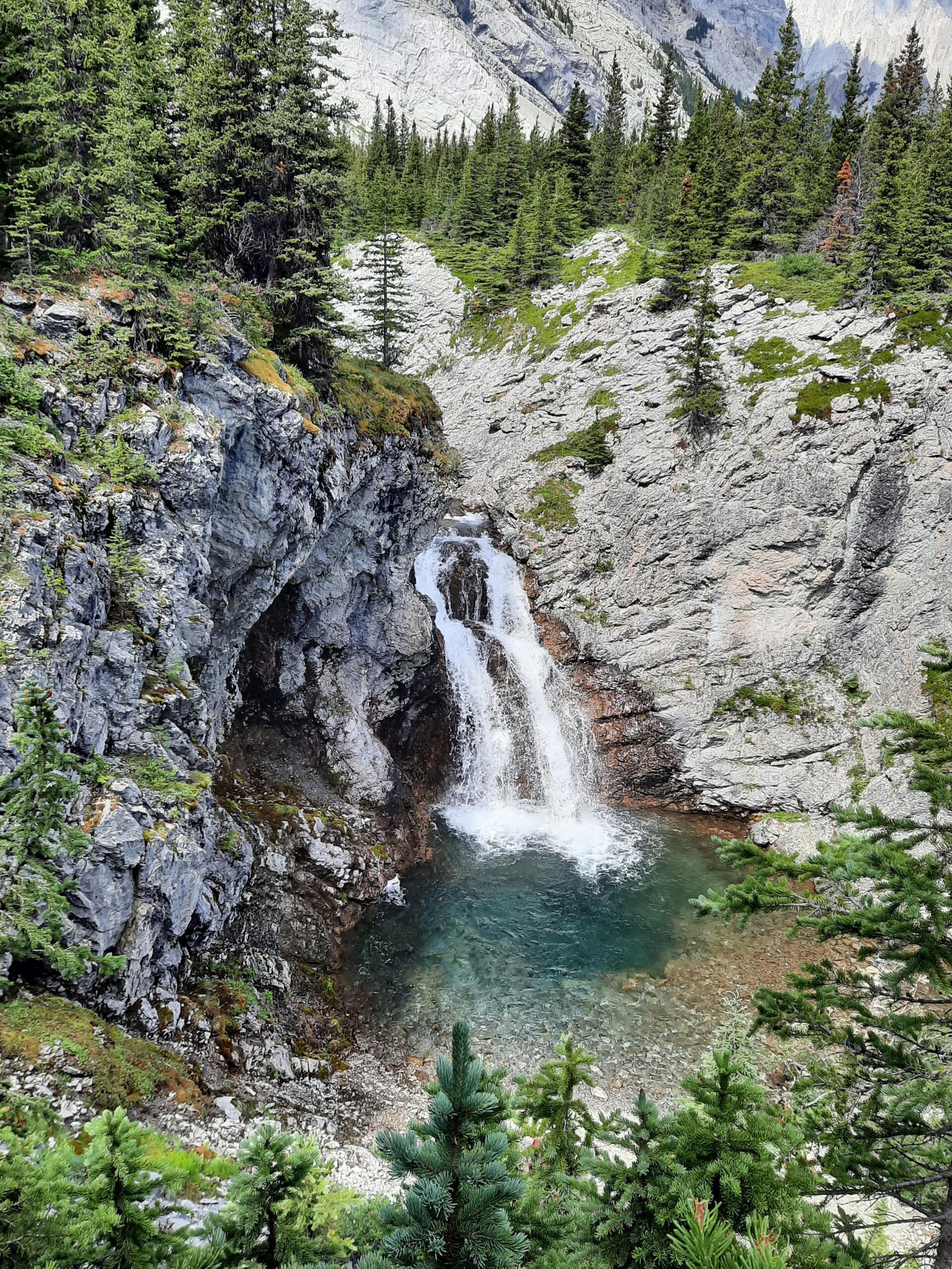
PTARMIGAN CIRQUE
Distance in and out: 4.5 km
Elevation gain: 210 m
Time to complete: 1.5 to 2 hours
Difficulty: Easy to Moderate
Ptarmigan Cirque delivers one of the most accessible alpine landscapes in the Canadian Rockies, and Alberta Parks explicitly describes it as a steep trail leading to a fragile alpine meadow and a spectacular mountain view from Highwood Meadows Day Use. That official description is concise, but it captures the essence of the hike well. You start high, you climb briefly, and the cirque opens quickly into a broad alpine bowl ringed by peaks. The payoff arrives early, but it still feels real.
This is one of those hikes that works because the terrain changes so quickly. The first part of the trail moves through subalpine cover, but the basin arrives before the day has time to flatten into routine. By midsummer, the meadow and surrounding slopes can be filled with alpine flowers, and current travel writeups still describe it as one of the most popular and family-friendly alpine hikes near Highwood Pass for exactly that reason: a lot of scenery for a relatively modest effort.
Ptarmigan Cirque is best for hikers who want a genuine alpine experience without committing to a long day. It also works well as a first Highwood Pass hike because it immediately shows what is different about the area: you do not spend half the day just reaching the alpine. You begin close to it.
ARETHUSA CIRQUE
Distance in and out: 4.6 km
Elevation gain: 230 m
Time to complete: 1.5 to 2 hours
Difficulty: Easy to Moderate
Arethusa Cirque is often mentioned alongside Ptarmigan Cirque, but the feel is slightly different. Recent route descriptions consistently frame it as one of the most scenic short hikes in the Highwood area, especially in larch season and wildflower season, while also noting that it is a little less obvious to casual visitors than Ptarmigan. That tends to be true in practice as well. It has the same basic advantage of rapid alpine access, but it often feels a little less like the “default” choice.
The trail rises through open slopes into a cirque basin rather than building toward a single ridge or summit. That makes the experience more about the shape of the terrain than about one particular viewpoint. In midsummer, the floral display can be exceptional. In autumn, the basin and surrounding slopes take on a different kind of beauty as the season shifts. The route’s short length is part of why it photographs so well: hikers are not exhausted by the time they reach the best terrain.
Arethusa is a strong choice for hikers who want a short alpine outing with visual variety, but who do not necessarily want the popularity or more obvious line of Ptarmigan Cirque. It is one of the best examples at Highwood of a short hike that still feels complete.
Learn More About Our Full-Day Arethusa Cirque Hike in Highwood Pass
POCATERRA RIDGE
Distance in and out: 9 km
Elevation gain: 650 m
Time to complete: 4 to 5 hours
Difficulty: Challenging
Pocaterra Ridge is widely considered one of the finest ridge hikes in Kananaskis Country, and current route descriptions still reflect that status very clearly. It is especially well known in late September when the larches turn, but it is not just a larch hike. It is a true ridge day, with a long alpine crest, broad views in multiple directions, and the kind of movement that keeps giving back as the route unfolds.
The day begins with a real climb, and that initial effort is what earns the ridge. Once on it, the terrain stretches out into the long, high line that makes Pocaterra memorable. Rather than arriving at one summit and being done, you continue through a sequence of high points and open walking, with Highwood Valley, the Front Ranges, and the Continental Divide country opening around you. In larch season, the contrast between the golden trees lower down and the open ridge above is a big part of the appeal.
Because so much of the route travels above treeline, weather matters here. Wind, cloud, and incoming systems change the experience quickly. Pocaterra is best for hikers who want a full alpine ridge day and who understand that the route’s quality lies in exposure, movement, and continuity, not just in a single summit photo.
GRIZZLY RIDGE
Distance in and out: 6 km
Elevation gain: 420 m
Time to complete: 2.5 to 3 hours
Difficulty: Moderate
Grizzly Ridge offers one of the quicker ways to reach broad alpine views from the Highwood Pass corridor. The public route information available today tends to show it grouped with Highwood Ridge or as part of loop/traverse days, which is a good reminder that this area is defined by open ridgelines and connected high terrain rather than neat, isolated single-objective hikes.
What makes Grizzly Ridge worthwhile is how quickly the day becomes open once you gain the crest. The effort is real, but it is not on the scale of a longer ridge traverse like Pocaterra. Instead, you get into viewpoint terrain quickly enough that the hike works well for people who want that broad Highwood perspective without committing to one of the bigger all-day lines. The views out over Highwood Valley and toward the surrounding peaks are exactly what many hikers come to this area for: alpine openness without a long valley approach.
This is a good fit for hikers who want a shorter ridge-style experience, especially if the goal is to spend time above treeline and not simply in a basin or meadow system. It suits stronger half-day hikers well.
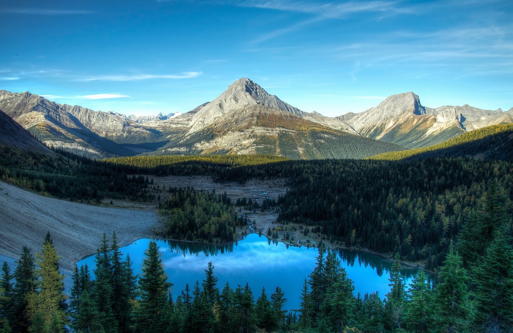
TYRWHITT MEADOWS
Distance in and out: 10 km
Elevation gain: 320 m
Time to complete: 3 to 4 hours
Difficulty: Moderate
Tyrwhitt Meadows lies beneath the slopes of Mount Tyrwhitt and offers a quieter alpine basin experience than the most popular cirque and ridge trails around the pass. The name itself suggests what the day is about. This is not primarily a summit route. It is a meadow-and-basin outing, and the reward is in the spread of the terrain rather than one concentrated viewpoint.
That makes it especially appealing in midsummer when the meadows are in bloom and the surrounding slopes frame the basin without forcing the whole day into a steep climb. The openness of the meadow system also helps disperse people a little more than on narrower trails. Even when the Highwood area is busy, a broad basin hike can still feel spacious in a way ridge routes sometimes do not.
Tyrwhitt Meadows is a strong choice for hikers who want alpine terrain without making the day about exposure or a demanding crest. It sits in a good middle ground: more alpine and open than many valley hikes, but less committed than the bigger ridges and glacier-oriented objectives nearby.
PICKLEJAR LAKES
Distance in and out: 12 km
Elevation gain: 600 m
Time to complete: 4 to 5 hours
Difficulty: Moderate to Challenging
Picklejar Lakes is one of the more rewarding longer alpine lake hikes in the Highwood area, and current route descriptions still point to it as a bit of a hidden gem despite its popularity among experienced local hikers. Alberta Parks’ trail listing flags it as not maintained, and recent route notes emphasize that the trailhead can be easy to miss and that navigation is less obvious than on the heavily signed Highwood Pass staples. That combination tells you a lot about the hike. It is beautiful, but it asks a little more of the hiker.
The route climbs into increasingly open terrain beneath steep rock walls before reaching the chain of small alpine lakes. What makes it special is the sense of depth. The lakes do not feel like a roadside destination or a quick alpine stop. You have to move into the landscape to get them, and once you do, the basin feels tucked back into the mountain walls in a way that is quite satisfying.
Picklejar is best for hikers who want a fuller day than the cirques and shorter ridges provide, but who still prefer a lake-and-basin destination over a fully exposed crest walk. It is one of the stronger “middle-to-longer day” choices in this zone.
RAE GLACIER
Distance in and out: 10 km
Elevation gain: 700 m
Time to complete: 4 to 5 hours
Difficulty: Challenging
Rae Glacier lies beneath the dramatic cliffs of Mount Rae along the southern Highwood region and gives the day a more rugged alpine-valley feel than some of the more famous ridge hikes around the pass. Current route pages group the outing with Mount Rae, and they also make clear that the upper mountain itself becomes a scramble. For a hiking article like this, the sensible stopping point is the glacier basin approach rather than overstating the route as a simple walk.
What distinguishes Rae Glacier is the severity of the setting. The upper basin is less meadow-like and more rock-and-ice oriented, which gives the whole outing a different emotional tone from the flower basins and rolling ridges around central Highwood Pass. You are moving toward harsher alpine terrain here, and that is part of the appeal for experienced hikers who want something more dramatic than a standard viewpoint or cirque day.
This is best suited to strong hikers comfortable with a more demanding outing and a rougher-feeling upper environment. It is not the first Highwood hike I would recommend, but it is one of the more dramatic ones.
MOUNT TYRWHITT RIDGE
Distance in and out: 11 km
Elevation gain: 720 m
Time to complete: 4 to 5 hours
Difficulty: Challenging
Mount Tyrwhitt Ridge offers a classic Highwood-style alpine ridge day: early access to open terrain, broad views, and a route whose character depends on staying above treeline for much of the outing. Public route pages today often fold Tyrwhitt into broader ridge traverses, which again reflects how this part of Highwood is built around connected alpine terrain rather than isolated single summits.
The strength of a route like this is not in one surprise reveal. It is in the sustained sense of exposure and perspective once the crest is reached. From the ridge, the valleys of southern Kananaskis and the Front Range peaks spread out in multiple directions, and the openness can make the route feel bigger than its numbers suggest. That is one reason weather matters so much here. On a clear, stable day, this kind of ridge is exhilarating. In poor conditions, it loses much of what makes it worthwhile.
This is best for hikers who actively want a high, open ridge experience rather than just “a hike with views.” It belongs with the stronger alpine objectives on the page.
HIGHWOOD RIDGE
Distance in and out: 8 km
Elevation gain: 520 m
Time to complete: 3 to 4 hours
Difficulty: Moderate to Challenging
Highwood Ridge is one of the more useful hikes in this area because it sits between the shorter viewpoint routes and the bigger all-day ridges. Current route descriptions place it among the stronger, view-heavy outings near the pass, and some hikers combine it with Grizzly Ridge into a larger loop or traverse. Even when done on its own, though, it offers a satisfying amount of crest walking for a moderate-to-challenging day.
The route climbs steadily into open terrain and then begins to feel expansive in the way Highwood does best. You are not buried in forest for long. The whole point is to get you into the open, and once that happens the ridge takes over the experience. Views stretch over the surrounding valleys and mountain ranges, and the day feels alpine in a very direct way.
Highwood Ridge is a good choice for hikers who want a meaningful alpine day without necessarily committing to the length or popularity of Pocaterra. It makes sense as a strong half-day or lighter full-day outing.
LITTLE HIGHWOOD PASS
Distance in and out: 6 km
Elevation gain: 350 m
Time to complete: 2.5 to 3 hours
Difficulty: Moderate
Little Highwood Pass is one of the quieter and less formalized outings on this list. Alberta Parks has a Little Highwood Pass day-use area, but recent public route notes make clear that the hiking itself can be less obvious, with portions that are poorly defined, muddy, or route-dependent. That is important context. This is not one of the polished, signed, high-traffic Highwood Pass classics.
For hikers who are comfortable with that, the appeal is exactly the quieter feel. The route moves away from the busiest parts of the main pass and into a stretch of terrain that can feel calmer, more spacious, and less used. That said, it is better understood as a route for hikers who are comfortable with navigation and lower trail definition than as a simple “moderate pass hike” in the same category as something like West Wind Pass in Spray Valley.
If you keep it on the page, I would present it as the quieter, less developed option for hikers who specifically want that feel, not as a general-recommendation trail for every visitor.
WHICH HIGHWOOD PASS HIKES SUIT DIFFERENT TYPES OF DAYS?
For shorter alpine outings, Ptarmigan Cirque and Arethusa Cirque are the clearest choices. They reach beautiful mountain terrain quickly and work well for hikers who want a high-alpine feel without committing to a long day. Ptarmigan is the more classic introduction. Arethusa feels a little quieter and a little more varied.
Moderate hikes like Grizzly Ridge and Tyrwhitt Meadows give more room to settle into the landscape while still delivering strong alpine scenery. Grizzly is better for a viewpoint-driven outing. Tyrwhitt Meadows is better if you want openness and basin character without making the day about exposure. Highwood Ridge sits just above that category and works well for hikers who want a more committed crest day without going all the way to Pocaterra-level scope.
For longer or more demanding alpine days, Pocaterra Ridge, Picklejar Lakes, Mount Tyrwhitt Ridge, and Rae Glacier are the stronger objectives. Pocaterra is the standout ridge hike. Picklejar is the best longer lake destination. Rae Glacier is the most rugged upper-basin outing. Matching the route to the season and to how you want the day to feel matters here, especially at elevation. That is also where pacing becomes important. I explore that further in How to Pace a Hike in the Canadian Rockies.
WILDFLOWER SEASON AT HIGHWOOD PASS
Highwood Pass is one of the best places in the Canadian Rockies to experience alpine wildflowers. Because the highway reaches such high elevation, you begin close to the terrain where bloom patterns become most dramatic. By midsummer, basins and slopes around Ptarmigan Cirque, Arethusa Cirque, and Tyrwhitt Meadows can be filled with color. Current travel and route descriptions continue to single out Ptarmigan and Arethusa in particular for strong floral displays.
The area’s floral reputation is one reason these hikes can become busy in peak bloom. Earlier starts usually make for a calmer experience, especially on weekends. For a fuller look at bloom timing and where flowers tend to show best, Wildflowers in Kananaskis is the right internal companion page.
PLANNING A HIKING DAY AT HIGHWOOD PASS
Highwood Pass sits at high elevation and is exposed to rapidly changing mountain weather. Alberta Parks’ Peter Lougheed trail report specifically reminds visitors to come prepared for a variety of conditions that can change suddenly through the day, including the possible need for extra layers and traction. That is a practical summary of why this area needs a bit more respect than its short approach distances might suggest.
Snow can linger in shaded terrain into early summer, while autumn storms can arrive quickly later in the season. The annual winter road closure through the pass runs from December 1 to June 14, which means access itself is seasonal before trail conditions are even considered.
When planning hikes in the region, see Best Time to Visit Kananaskis for Hiking. Understanding how weather shifts in alpine terrain is also important, and How Hiking Guides Read Mountain Weather in the Rockies is the strongest internal support page for that. For broader seasonal context, Banff Weather by Month is also useful.
Visitors should also remember that hiking within Kananaskis Country requires a Kananaskis Conservation Pass. Alberta Parks lists that requirement clearly on trail and day-use pages across the region.
WHAT TO KNOW BEFORE SETTING OUT
The Highwood Pass region contains important wildlife habitat, including grizzly bear country, and Alberta Parks’ current reporting and day-use advisories make clear that closures and wildlife considerations can affect access in nearby parts of Peter Lougheed and Highwood terrain. Carrying bear spray, checking current trail conditions, and choosing routes appropriate to the season are all part of a normal day here, not special precautions.
This is also where many hikes can feel more demanding than expected simply because you are already at elevation and often exposed early in the outing. I explore that further in When a Guided Day Feels Harder Than It Should
Because many trails begin directly at or near the pass, parking areas can fill quickly during peak summer weekends and flower season. Starting earlier in the day usually leads to a more relaxed experience on the trail.
A HIGH-ALPINE EXPERIENCE IN KANANASKIS
Highwood Pass offers one of the most immediate alpine hiking experiences in the Canadian Rockies. Within a short distance of the highway, hikers can reach sweeping ridgelines, flower-filled basins, and dramatic viewpoints overlooking the Front Ranges. That combination of high starting elevation, strong scenery, and route variety is what makes the area so memorable.
For many visitors exploring Kananaskis Country, Highwood Pass becomes the place where they realize how different alpine hiking can feel when you begin near treeline instead of spending hours walking toward it. That is its real distinction.
A GUIDE’S PERSPECTIVE
As a private hiking guide working across the Canadian Rockies, I spend much of the season moving through landscapes like these with guests who want a steady, well-paced day in the mountains.
Trails such as these are often chosen not only for scenery, but for how they match the day’s conditions, the group’s energy, and how crowded certain corridors may feel at different times. Highwood Pass is especially sensitive to that because the terrain opens so quickly. A day can feel wonderfully expansive, or more exposed and committing than expected, depending on weather, timing, and the kind of route chosen.
This kind of decision-making is often what allows a day to feel calm in the mountains. I describe that more fully in Margin Is What Makes a Day Feel Calm.
If you prefer exploring these landscapes with a thoughtful pace and experienced mountain judgment, you can learn more about my private guided hiking experiences in Kananaskis.
FREQUENTLY ASKED QUESTIONS ABOUT HIGHWOOD PASS HIKING
Why are hikes at Highwood Pass different from other Rockies hikes?
Highwood Pass sits at 2,206 metres, so hikers start the day already near treeline. That means many trails reach open alpine terrain very quickly compared with hikes that begin lower in valley bottoms.
Is Highwood Pass good for alpine hiking without a long climb?
Yes. That is one of its biggest advantages. Ptarmigan Cirque, Arethusa Cirque, and several ridge hikes access alpine scenery far faster than many comparable Rockies trails.
Are wildflowers common at Highwood Pass?
Yes. Highwood Pass is one of the strongest alpine flower areas in Kananaskis, particularly in midsummer around Ptarmigan Cirque, Arethusa Cirque, and Tyrwhitt Meadows.
Is Highwood Pass suitable for a half-day hike?
Many hikes near the pass work very well as shorter alpine outings. Ptarmigan Cirque, Arethusa Cirque, Grizzly Ridge, and sometimes Highwood Ridge all offer strong scenery within a few hours, depending on pace and conditions.
Why does the Highwood Pass road close in winter?
Highway 40 through Highwood Pass closes seasonally from December 1 to June 14. Alberta Parks lists this annual closure on current trail reporting for the area.
Do hikers need to prepare differently for Highwood Pass?
Yes. Because the pass sits at high elevation, conditions can change quickly. Even in summer, hikers should be prepared for wind, cooler temperatures, and rapidly shifting alpine weather.
Certified private hiking guide and professional interpretive practitioner based in the Canadian Rockies. With over 25 years of four-season mountain experience, she offers thoughtfully paced hiking experiences that help active adults explore mountain landscapes with care, confidence, and understanding. Meet Niki